Click Here to View Large Map or to Purchase
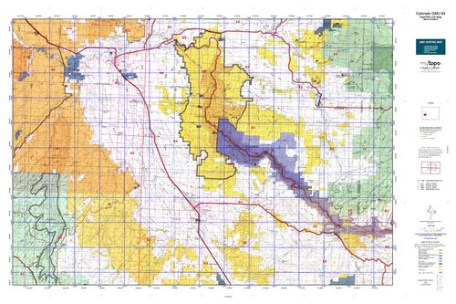
Colorado Unit 64 Hunting Topo Map with Printed Boundaries
Hunters Domain has Colorado Unit 64 hunt area maps that are 1:100,000-scale maps using Bureau of Land Management land status base maps.
Our UNIT 64 maps include:
Colorado public land ownership boundaries
Topographical contour lines
1:100,000 scale for easy viewing
Roads printed
Key terrain features to help you plan your hunt or trip
Hunt area or game management unit 64 (GMU 64) boundary is overlaid on the BLM base map
Easy planning for your upcoming big game hunt by defining roads and routes into the preferred area
Custom maps for Unit 64 are also available (See it all on one map):
Color aerial photo maps: high resolution (you define borders/boundaries)
TOPO maps only where you easily define borders or edges of maps with our online program
Hybrid maps: a unique and detailed aerial photo combined with a USGS topographical maps (user-defined boundaries)
Order your Colorado Unit 64 Map Today!
The actual boundary description/definitions printed below from Colorado Parks and Wildlife hunting regulations brochure could have errors or been amended by the state so always check in their most current printed regulations or the Colorado Parks and Wildlife website to verify these boundaries before hunting as these are for reference only.
Colorado Big Game Unit 64
– Unit 64 Topo/Map Colorado – Game Management Unit (GMU-64).
Game Management Unit (GMU)
BLM Maps:
Reservation Land
US Forest Service Maps:
Reservation land
Click Here to Order Your Colorado Unit 64 Topo Map
Colorado Unit 64 Description
Unit 64 Cimarron River Drainage Region: Delta and Montrose Counties bounded on the North and the East by Colorado Hwy 92 to Gunnison River, south to Morrow Point Res.; on the East by Big Blue Creek; on the South and the West by U.S. 50.
These units include some of the most diverse terrain in Colorado, from 4,700 feet in the dry desert lands near Delta to 14,309-foot Uncompahgre Peak. Warm weather at the low elevations will cause meat to spoil very quickly, so be prepared to pack out fast. Weather is variable and unpredictable at the higher elevations. Most of GMU 64 is private land or part of Black Canyon of the Gunnison National Park where hunting is prohibited.


Reviews
There are no reviews yet.