Arizona Unit 12 B Topo Maps Hunting & Unit Maps

arizona unit 12 b topo map

Arizona Unit 12 B Topo Maps Hunting & Unit Maps

Currently there are 20 peoples are currently looking at this product

Spend $1,000.00 for FREE SHIPPING

Description
Customer Review

Reviews

There are no reviews yet.

Be the first to review “Arizona Unit 12 B Topo Maps Hunting & Unit Maps”

Your email address will not be published. Required fields are marked *

Click Here to View Large Map or Order

Arizona Unit 12 B hunting map topo with printed boundaries

HuntersDomain has Arizona unit 12 B hunt area maps that are 1:100,000-scale maps using Bureau of Land Management land status base maps.

Our UNIT 12 B maps include:

  1. Arizona public land ownership boundaries
  2. Topographical contour lines
  3. 1:100,000 scale for easy viewing
  4. Roads printed
  5. Key terrain features to help you plan your hunt or trip
  6. Hunt area or game management unit 12 B (GMU 12 B) boundary is overlaid on the BLM base map
  7. Easy planning for your upcoming big game hunt by defining roads and routes into the preferred area

Custom maps for unit 12 B are also available (See it all on one map):

  1. Color aerial photo maps: high resolution (you define borders/boundaries)
  2. TOPO maps only where you easily define borders or edges of maps with our online program
  3. Hybrid maps: a unique and detailed aerial photo combined withe USGS topographical maps (user defined boundaries)

Order your unit 12 B Arizona topo map today!

The actual boundary description/definitions printed below from the Arizona Division of Wildlife hunting regulations brochure could have errors or been amended by the state so always check in their most current printed regulations or the Arizona Division of Wildlife website to verify these boundaries before hunting as these are for reference only.

Arizona Big Game

Click Here to Order Unit 12 B Topo Map

Unit description

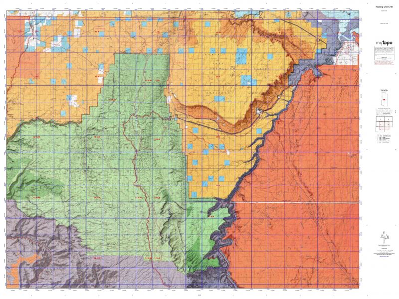
Unit 12 B Beginning at United States Highway 89A and the Kaibab National Forest boundary near milepost 566; southerly and easterly along the forest boundary to Grand Canyon National Park; northeasterly along the park boundary to Glen Canyon National Recreation area; easterly along the recreation area boundary to the Colorado River; northeasterly along the Colorado River to the Arizona-Utah state line; westerly along the state line to Kanab Creek; southerly along Kanab Creek to the Kaibab National Forest boundary; northerly, easterly, and southerly along this boundary to United States Highway 89A near milepost 566; except those portions that are sovereign tribal lands of the Kaibab Band of Paiute Indians.


Shopping cart
Sign in

No account yet?

Start typing to see products you are looking for.
Shop
0 Wishlist
0 items Cart
My account