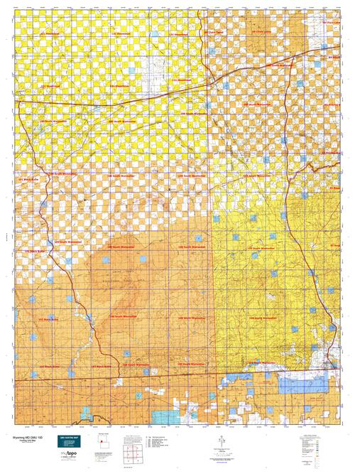
Wyoming Unit 100 Mule Deer Hunting Topo Map with Printed Boundaries
Hunters Domain has Wyoming Unit 100 Mule Deer hunt area maps that are 1:100,000-scale maps using Bureau of Land Management land status base maps.
Our UNIT 100 Mule Deer maps include:
Mule Deer public land ownership boundaries
Topographical contour lines
1:100,000 scale for easy viewing
Roads printed
Key terrain features to help you plan your hunt or trip
Hunt area or game management unit 100 (GMU 100) boundary is overlaid on the BLM base map
Easy planning for your upcoming big game hunt by defining roads and routes into the preferred area
Custom maps for Unit 100 are also available (See it all on one map):
TOPO maps only where you easily define borders or edges of maps with our online program
Hybrid maps: a unique and detailed aerial photo combined with a USGS topographical maps (user-defined boundaries)
Order your Wyoming Unit 100 Mule Deer Map Today!
The actual boundary description/definitions printed below from Wyoming Game and Fish hunting regulations brochure could have errors or been amended by the state so always check in their most current printed regulations or the Wyoming Game and Fish website to verify these boundaries before hunting as these are for reference only.
Wyoming Unit 100 Mule Deer
– Unit 100 Topo/Map Wyoming Mule Deer – Game Management Unit (GMU-100).
Game Management Unit (GMU)
BLM Maps:
Reservation Land
US Forest Service Maps:
Reservation land
Wyoming Unit 100 Mule Deer Description
Much of this unit is composed of semi-arid sage brush plains. The southern and western edges of this area have badlands characterized by broken terrain with sporadic juniper, mountain mahogany, sage brush, and gardners saltbush. Vegetation and forage for deer is significantly limited to folds and aspects of terrain which hold moisture from infrequent rainfall or snow melt.
Finding mule deer in area 100 is largely predicated on resource availability. Deer hunters in area 100 should be looking for water, cover, and browse forage. Water from perennial springs located in the Sand and Willow Creek watersheds area utilized by deer through the growing season and subsequently into the hunting season. Cover in these desert ecosystems is typically marginal and limited to boulders, tall sage brush, or gullies deep enough to conceal a deer. Hunters often have success locating deer in the afternoon when the aspect of the sun has changed the direction and location of shaded areas, forcing deer to get out of their beds and reposition. Forage availability is also marginal where deer browse in the summer and fall months seems to primarily consist of gardners saltbush, mountain mahogany, and sage brush, though deer have been observed consuming greasewood and rabbit brush. Hunters should enter this unit with reasonable expectations of seeing low numbers of mule deer, however the vast amount of remote habitat and low harvest rates help to allow a handful of bucks reach trophy size potential.


Reviews
There are no reviews yet.