Oregon Unit 38 Topo Maps Hunting & Unit Maps

Oregon Unit 38 Topo Maps Hunting & Unit Maps

Currently there are 20 peoples are currently looking at this product

Spend $1,000.00 for FREE SHIPPING

Description
Customer Review

Reviews

There are no reviews yet.

Be the first to review “Oregon Unit 38 Topo Maps Hunting & Unit Maps”

Your email address will not be published. Required fields are marked *

Click Here to View Large Map or Order

Oregon Unit 38 hunting map topo with printed boundaries

HuntersDomain has Oregon unit 38 hunt area maps that are 1:100,000-scale maps using Bureau of Land Management land status base maps.

Our UNIT 38 maps include:

  1. Oregon public land ownership boundaries
  2. Topographical contour lines
  3. 1:100,000 scale for easy viewing
  4. Roads printed
  5. Key terrain features to help you plan your hunt or trip
  6. Hunt area or game management unit 38 (GMU 38) boundary is overlaid on the BLM base map
  7. Easy planning for your upcoming big game hunt by defining roads and routes into the preferred area

Custom maps for unit 38 are also available (See it all on one map):

  1. Color aerial photo maps: high resolution (you define borders/boundaries)
  2. TOPO maps only where you easily define borders or edges of maps with our online program
  3. Hybrid maps: a unique and detailed aerial photo combined with a USGS topographical maps (user-defined boundaries)

Order your unit 38 Oregon topo map today!

The actual boundary description/definitions printed below from the Oregon Division of Wildlife hunting regulations brochure could have errors or been amended by the state so always check in their most current printed regulations or the Oregon Division of Wildlife website to verify these boundaries before hunting as these are for reference only.

Oregon Big Game

– (Moffat) bounded on N, East, and South by Green River; on West by Utah.

Click Here to Order Unit 38 Topo Map

Unit description

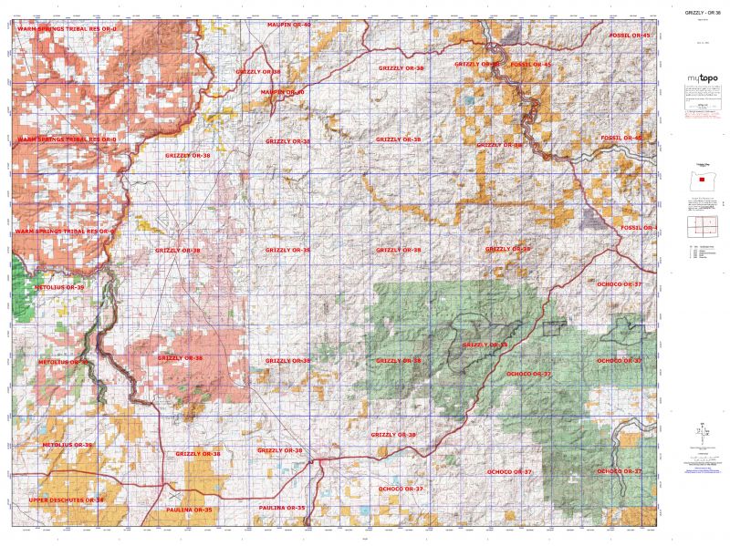
GRIZZLY 28% of public lands. Beginning at Redmond; north on United States Highway 97 to Crooked River; north on Crooked River and Deschutes River to S Junction; northeast on S Junction Company Road to Highway 97 and United States Highway 197; south on Highway 97 to Antelope Circle Road; northeast on Antelope Circle Road to Antelope; east on Highway 218 to John Day River at Clarno; southeast on John Day River to Bridge Circle; southeast on Bridge Circle to United States Highway 26 near Mitchell; southwest on Highway 26 to Prineville; west on United States Highway 126 to Redmond, point of beginning. (Maps: Ochoco National Forest, Prineville Bureau of Land Management)


Shopping cart
Sign in

No account yet?

Start typing to see products you are looking for.
Shop
0 Wishlist
0 items Cart
My account