Nevada Hunting Unit 43 Topo Maps

Nevada Hunting Unit 43 Topo Maps

Currently there are 20 peoples are currently looking at this product

Spend $1,000.00 for FREE SHIPPING

Description
Customer Review

Reviews

There are no reviews yet.

Be the first to review “Nevada Hunting Unit 43 Topo Maps”

Your email address will not be published. Required fields are marked *

Click Here to View Large Map or Order

Nevada Unit 43 hunting map topo with printed boundaries

HuntersDomain has Nevada unit 43 hunt area maps that are 1:100,000-scale maps using Bureau of Land Management land status base maps.

Our UNIT 43 maps include:

  1. Nevada public land ownership boundaries
  2. Topographical contour lines
  3. 1:100,000 scale for easy viewing
  4. Roads printed
  5. Key terrain features to help you plan your hunt or trip
  6. Hunt area or game management unit 43 (GMU 43) boundary is overlaid on the BLM base map
  7. Easy planning for your upcoming big game hunt by defining roads and routes into the preferred area

Custom maps for unit 43 are also available (See it all on one map):

  1. Color aerial photo maps: high resolution (you define borders/boundaries)
  2. TOPO maps only where you easily define borders or edges of maps with our online program
  3. Hybrid maps: a unique and detailed aerial photo combined withe USGS topographical maps (user-defined boundaries)

Order your unit 43 Nevada topo map today!

The actual boundary description/definitions printed below from the Nevada Division of Wildlife hunting regulations brochure could have errors or been amended by the state so always check in their most current printed regulations or the Nevada Division of Wildlife website to verify these boundaries before hunting as these are for reference only.

Nevada Big Game Unit 43

– Unit 43 Topo/Map Nevada – Game Management Unit (GMU-43).

Game Management Unit (GMU)

BLM Maps:

Reservation Land

US Forest Service Maps:

Reservation land

Click Here to Order Unit 43 Topo Map

Unit description

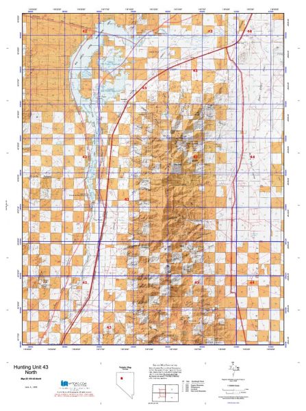
Unit 43: Those portions of Pershing and Churchill counties bounded on the north and west by Interstate Highway No. 80 that runs between Mill City and U.S. Highway No. 95, thence south approximately 7 miles along U.S. Highway No. 95 to its junction with the Packard Wash Road, on the south by the Packard Wash Road that travels along the southeastern base of the West Humboldt Range and across Packard Wash to the intersection with the Stillwater–Iron Mine Road, thence north along the Stillwater–Iron Mine Road to its intersection with the Coal Canyon Road, thence northwest along the Coal Canyon Road to its intersection with the McKinney Pass Road, thence eastward along the McKinney Pass Road to the intersection of the Buena Vista Valley Road, and on the east by the Buena Vista Valley Road that travels north along the base of the Humboldt Range to the intersection with state Route No. 400 east of Unionville, thence north on state Route No. 400 to its intersection with Interstate Highway No. 80 at Mill City.


Shopping cart
Sign in

No account yet?

Start typing to see products you are looking for.
Shop
0 Wishlist
0 items Cart
My account