Idaho Hunting Unit 11A Palouse Topo Maps

Idaho Hunting Unit 11A Palouse Topo Maps

Currently there are 20 peoples are currently looking at this product

Spend $1,000.00 for FREE SHIPPING

Description
Customer Review

Reviews

There are no reviews yet.

Be the first to review “Idaho Hunting Unit 11A Palouse Topo Maps”

Your email address will not be published. Required fields are marked *

Click Here to View Large Map or Order

Idaho Unit 11A hunting map topo with printed boundaries

HuntersDomain has Idaho unit 11A hunt area maps that are 1:100,000-scale maps using Bureau of Land Management land status base maps.

Our UNIT 11A maps include:

  1. Idaho public land ownership boundaries
  2. Topographical contour lines
  3. 1:100,000 scale for easy viewing
  4. Roads printed
  5. Key terrain features to help you plan your hunt or trip
  6. Hunt area or game management unit 11A (GMU 11A) boundary is overlaid on the BLM base map
  7. Easy planning for your upcoming big game hunt by defining roads and routes into the preferred area

Custom maps for unit 11A are also available (See it all on one map):

  1. Color aerial photo maps: high resolution (you define borders/boundaries)
  2. TOPO maps only where you easily define borders or edges of maps with our online program
  3. Hybrid maps: a unique and detailed aerial photo combined with a USGS topographical maps (user-defined boundaries)

Order your unit 11A Idaho topo map today!

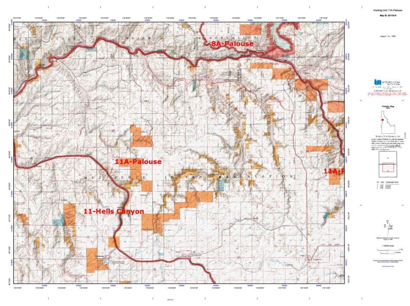
The actual boundary description/definitions printed below from Idaho Division of Wildlife hunting regulations brochure could have errors or been amended by the state so always check in their most current printed regulations or the Idaho Division of Wildlife website to verify these boundaries before hunting as these are for reference only.

Idaho Big Game Unit 11A

– Unit 11A Topo/Map Idaho – Game Management Unit (GMU-11A).

Game Management Unit (GMU)

BLM Maps:

Reservation Land

US Forest Service Maps:

Reservation land

Click Here to Order Unit 11A Topo Map

Unit description

Unit 11A Palouse: Those portions of Clearwater, Nez Perce, Lewis, and Idaho counties within the following boundary: beginning on the Clearwater River at the United States 95 bridge near Spalding, upstream (excluding islands) to the South Fork of the Clearwater River, then up the South Fork to Harpster Bridge, then southwest on State Highway 13 to United States 95 at Grangeville, then northwest on United States 95 to Spalding, the point of beginning. Nez Perce National Historical Park – closed.


Shopping cart
Sign in

No account yet?

Start typing to see products you are looking for.
Shop
0 Wishlist
0 items Cart
My account