
Nevada Hunting Unit 282 Topo Maps
Sold out
Nevada Hunting Unit 282 Topo Maps
Currently there are 20 peoples are currently looking at this product
Spend $1,000.00 for FREE SHIPPING
Description
Customer Review
Be the first to review “Nevada Hunting Unit 282 Topo Maps” Cancel reply
Click Here to View Large Map or Order
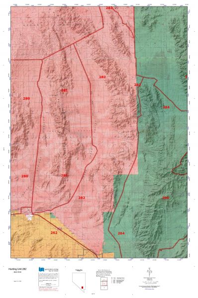
Nevada Unit 282 hunting map topo with printed boundaries
HuntersDomain has Nevada unit 282 hunt area maps that are 1:100,000-scale maps using Bureau of Land Management land status base maps.
Our UNIT 282 maps include:
- Nevada public land ownership boundaries
- Topographical contour lines
- 1:100,000 scale for easy viewing
- Roads printed
- Key terrain features to help you plan your hunt or trip
- Hunt area or game management unit 282 (GMU 282) boundary is overlaid on the BLM base map
- Easy planning for your upcoming big game hunt by defining roads and routes into the preferred area
Custom maps for unit 282 are also available (See it all on one map):
- Color aerial photo maps: high resolution (you define borders/boundaries)
- TOPO maps only where you easily define borders or edges of maps with our online program
- Hybrid maps: a unique and detailed aerial photo combined with a USGS topographical maps (user-defined boundaries)
Order your unit 282 Nevada topo map today!
The actual boundary description/definitions printed below from the Nevada Division of Wildlife hunting regulations brochure could have errors or been amended by the state so always check in their most current printed regulations or the Nevada Division of Wildlife website to verify these boundaries before hunting as these are for reference only.
– Unit 282 Topo/Map Nevada – Game Management Unit (GMU-282).
Game Management Unit (GMU)
BLM Maps:
Reservation Land
US Forest Service Maps:
Reservation land
Click Here to Order Unit 282 Topo Map
Unit description
Unit 282: That portion of Clark and Lincoln counties bounded as follows: Beginning at the Corn Creek Station on the Alamo Road, thence north on that road to the Desert Dry Lake, thence northwest on the Desert Valley Target Road, thence north along the boundary of the Nellis Air Force Range approximately 7 miles, thence northwesterly along the drainage to and beyond the summit between the Desert Hills and the Pahranagat Range to the Desert Valley Target Road, thence south on that road approximately 5.5 miles to a point at longitude 115°24’30″W. and latitude 37°04’55″N., thence southwesterly to a point at longitude 115°30’43″W. and latitude 37°02’32″N., thence southeasterly to Dog Bone Lake, thence along the Three Lakes Valley Road to U.S. Highway No. 95, thence southeasterly along U.S. Highway No. 95, and thence along the Corn Creek Station Road to Corn Creek Station.


Reviews
There are no reviews yet.