
Idaho Hunting Unit 66 Tex Creek Topo Maps
Sold out
Idaho Hunting Unit 66 Tex Creek Topo Maps
Currently there are 20 peoples are currently looking at this product
Spend $1,000.00 for FREE SHIPPING
Description
Customer Review
Be the first to review “Idaho Hunting Unit 66 Tex Creek Topo Maps ” Cancel reply
Click Here to View Large Map or Order
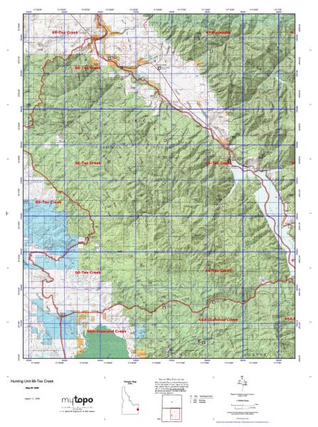
Idaho Unit 66 hunting map topo with printed boundaries
HuntersDomain has Idaho unit 66 hunt area maps that are 1:100,000-scale maps using Bureau of Land Management land status base maps.
Our UNIT 66 maps include:
- Idaho public land ownership boundaries
- Topographical contour lines
- 1:100,000 scale for easy viewing
- Roads printed
- Key terrain features to help you plan your hunt or trip
- Hunt area or game management unit 66 (GMU 66) boundary is overlaid on the BLM base map
- Easy planning for your upcoming big game hunt by defining roads and routes into the preferred area
Custom maps for unit 66 are also available (See it all on one map):
- Color aerial photo maps: high resolution (you define borders/boundaries)
- TOPO maps only where you easily define borders or edges of maps with our online program
- Hybrid maps: a unique and detailed aerial photo combined with a USGS topographical maps (user-defined boundaries)
Order your unit 66 Idaho topo map today!
The actual boundary description/definitions printed below from Idaho Division of Wildlife hunting regulations brochure could have errors or been amended by the state so always check in their most current printed regulations or the Idaho Division of Wildlife website to verify these boundaries before hunting as these are for reference only.
– Unit 66 Topo/Map Idaho – Game Management Unit (GMU-66).
Game Management Unit (GMU)
BLM Maps:
Reservation Land
US Forest Service Maps:
Reservation land
Click Here to Order Unit 66 Topo Map
Unit description
Unit 66 Tex Creek: Those portions of Bingham and Bonneville counties within the following boundary: Beginning at the Idaho-Wyoming state line on the South Fork of the Snake River, then down the center of Palisades Reservoir to Palisades Dam, then downstream along the mean high water line on the south shore of the South Fork of the Snake River to the Swan Valley bridge on United States 26, then northwest of United States 26 to the watershed divide between Granite and Garden Creeks, then southwest along the divide and the divides between Garden- Antelope Creeks, Antelope-Pritchard Creeks, and Fall Tex Creeks to the Fall Creek Road (Forest Service Road 077), then west on Fall Creek Road to Skyline Ridge Road (Forest Service Road 077), then south on Skyline Ridge Road to Brockman Guard Station, then down Brockman Creek to Grays Lake outlet, then upstream along the outlet to the Bone-Grays Lake Road, then east on Bone-Grays Lake Road to the McCoy Creek Road (Forest Service Road 087), then east on the McCoy Creek Road to the Idaho-Wyoming state line, then north to the point of beginning.


Reviews
There are no reviews yet.