Idaho Hunting Unit 20 Selway Topo Maps

Idaho Hunting Unit 20 Selway Topo Maps

Currently there are 20 peoples are currently looking at this product

Spend $1,000.00 for FREE SHIPPING

Description
Customer Review

Reviews

There are no reviews yet.

Be the first to review “Idaho Hunting Unit 20 Selway Topo Maps”

Your email address will not be published. Required fields are marked *

Click Here to View Large Map or Order

Idaho Unit 20 hunting map topo with printed boundaries

HuntersDomain has Idaho unit 20 hunt area maps that are 1:100,000-scale maps using Bureau of Land Management land status base maps.

Our UNIT 20 maps include:

  1. Idaho public land ownership boundaries
  2. Topographical contour lines
  3. 1:100,000 scale for easy viewing
  4. Roads printed
  5. Key terrain features to help you plan your hunt or trip
  6. Hunt area or game management unit 20 (GMU 20) boundary is overlaid on the BLM base map
  7. Easy planning for your upcoming big game hunt by defining roads and routes into the preferred area

Custom maps for unit 20 are also available (See it all on one map):

  1. Color aerial photo maps: high resolution (you define borders/boundaries)
  2. TOPO maps only where you easily define borders or edges of maps with our online program
  3. Hybrid maps: a unique and detailed aerial photo combined with a USGS topographical maps (user-defined boundaries)

Order your unit 20 Idaho topo map today!

The actual boundary description/definitions printed below from Idaho Division of Wildlife hunting regulations brochure could have errors or been amended by the state so always check in their most current printed regulations or the Idaho Division of Wildlife website to verify these boundaries before hunting as these are for reference only.

Idaho Big Game Unit 20

– Unit 20 Topo/Map Idaho – Game Management Unit (GMU-20).

Game Management Unit (GMU)

BLM Maps:

Reservation Land

US Forest Service Maps:

Reservation land


Click Here to Order Unit 20 Topo Map

Unit description

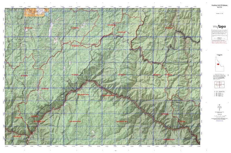
Unit 20 Selway: That portion of Idaho County within the following boundary: beginning at the mouth of the South Fork of the Salmon River, then north along the Mackay Bar-Red River Ranger Station Road (Forest Service Road 222.3) to the Montana Road, then east along Montana Road to the Green Mountain-Elk Mountain Road, then northeast along Green Mountain-Elk Mountain Road to the watershed divide between the Selway and Salmon Rivers around the head of Bargamin Creek, then southeast along the divide over Three Prong Mountain, Burnt Knob, Salmon Mountain and Waugh Mountain, then south down Waugh Ridge to the Salmon River, then downstream to the South Fork of the Salmon River, the point of beginning.


Shopping cart
Sign in

No account yet?

Start typing to see products you are looking for.
Shop
0 Wishlist
0 items Cart
My account