Click Here to View Large Map or to Purchase
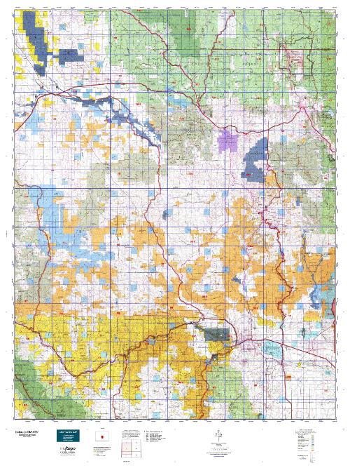
Colorado Unit 581 Hunting Topo Map with Printed Boundaries
Hunters Domain has Colorado Unit 581 hunt area maps that are 1:100,000-scale maps using Bureau of Land Management land status base maps.
Our UNIT 581 maps include:
Colorado public land ownership boundaries
Topographical contour lines
1:100,000 scale for easy viewing
Roads printed
Key terrain features to help you plan your hunt or trip
Hunt area or game management unit 581 (GMU 581) boundary is overlaid on the BLM base map
Easy planning for your upcoming big game hunt by defining roads and routes into the preferred area
Custom maps for Unit 581 are also available (See it all on one map):
Color aerial photo maps: high resolution (you define borders/boundaries)
TOPO maps only where you easily define borders or edges of maps with our online program
Hybrid maps: a unique and detailed aerial photo combined with a USGS topographical maps (user-defined boundaries)
Order your Colorado Unit 581 Map Today!
The actual boundary description/definitions printed below from Colorado Parks and Wildlife hunting regulations brochure could have errors or been amended by the state so always check in their most current printed regulations or the Colorado Parks and Wildlife website to verify these boundaries before hunting as these are for reference only.
Colorado Big Game Unit 581
– Unit 581 Topo/Map Colorado – Game Management Unit (GMU-581).
Game Management Unit (GMU)
BLM Maps:
Reservation Land
US Forest Service Maps:
Reservation land
Click Here to Order Your Color Colorado Unit 581 Hunting Map
Colorado Unit 581 Description
Unit 581 Located in Park, Teller and Freemont Counties bounded on the North by U.S. 24; on the East by Colorado 67 and Phantom Canyon Rd.; on the South by U.S. 50; on the West by Colorado 9 and Park CRs 59 and 102.
GMU 581 Elevation: 10,863 feet on Stoll Mountain to 5,250 feet near Canon City. Terrain: Level bottom lands to moderately steep hills to steep mountains. Vegetation: Grassy, shrub, piñon, juniper in low areas to spruce & fir at higher elevations. Weather: Variable, but first snow or freeze can occur in early to mid-Sept. Land Status: Only 35 percent public. Hunter Access: Fair to good. Some public lands blocked by private property. Minimal hunting near subdivisions. Deer: Winter concentration for mule deer is generally in the northern and western portions of this unit. Recommended areas include Puma Hills and Eleven Mile Canyon in the northwestern portion. In the western portion, look toward Witcher Mountain and Cap Rock Ridge. Elk: This unit tends to be a winter concentration area for elk, especially the western and northeastern portion of the unit. In the northeast, look toward Dome Rock SWA and
Sheep Rock. In the west, look toward Witcher Mountain and Cap Rock Ridge. Pronghorn: Good pronghorn hunting in the northwest part of the unit, especially north of Eleven Mile State Park. This area is mainly private, making access difficult. Some pronghorn may be found on the south side of the park as well.


Reviews
There are no reviews yet.