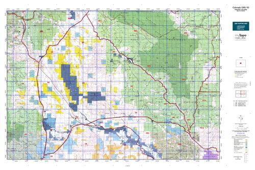
Colorado Unit 50 Hunting Topo Map with Printed Boundaries
Hunters Domain has Colorado Unit 50 hunt area maps that are 1:100,000-scale maps using Bureau of Land Management land status base maps.
Our UNIT 50 maps include:
Colorado public land ownership boundaries
Topographical contour lines
1:100,000 scale for easy viewing
Roads printed
Key terrain features to help you plan your hunt or trip
Hunt area or game management unit 50 (GMU 50) boundary is overlaid on the BLM base map
Easy planning for your upcoming big game hunt by defining roads and routes into the preferred area
Custom maps for Unit 50 are also available (See it all on one map):
Color aerial photo maps: high resolution (you define borders/boundaries)
TOPO maps only where you easily define borders or edges of maps with our online program
Hybrid maps: a unique and detailed aerial photo combined with a USGS topographical maps (user-defined boundaries) Order your Colorado Unit 50 Map Today!
The actual boundary description/definitions printed below from Colorado Parks and Wildlife hunting regulations brochure could have errors or been amended by the state so always check in their most current printed regulations or the Colorado Parks and Wildlife website to verify these boundaries before hunting as these are for reference only.
Colorado Big Game Unit 50
– Unit 50 Topo/Map Colorado – Game Management Unit (GMU-50).


Reviews
There are no reviews yet.