Click Here to View Large Map or to Purchase
Colorado Unit 201 Hunting Topo Map with Printed Boundaries
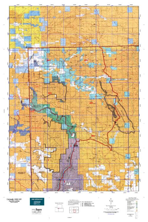
Hunters Domain has Colorado Unit 201 hunt area maps that are 1:100,000-scale maps using Bureau of Land Management land status base maps.
Our UNIT 201 maps include:
Colorado public land ownership boundaries
Topographical contour lines
1:100,000 scale for easy viewing
Roads printed
Key terrain features to help you plan your hunt or trip
Hunt area or game management unit 201 (GMU 201) boundary is overlaid on the BLM base map
Easy planning for your upcoming big game hunt by defining roads and routes into the preferred area
Custom maps for Unit 201 are also available (See it all on one map):
Color aerial photo maps: high resolution (you define borders/boundaries)
TOPO maps only where you easily define borders or edges of maps with our online program
Hybrid maps: a unique and detailed aerial photo combined with a USGS topographical maps (user-defined boundaries)
Order your Colorado Unit 201 Map Today!
The actual boundary description/definitions printed below from Colorado Parks and Wildlife hunting regulations brochure could have errors or been amended by the state so always check in their most current printed regulations or the Colorado Parks and Wildlife website to verify these boundaries before hunting as these are for reference only.
Colorado Big Game Unit 201
– Unit 201 Topo/Map Colorado – Game Management Unit (GMU-201).
Game Management Unit (GMU)
BLM Maps:
Reservation Land
US Forest Service Maps:
Reservation land
Click Here to Order Your Color Colorado Unit 201 Topo Map
Colorado Unit 201 Description
Unit 201 Located in Moffat County bounded on the North by Wyoming border; on the East by CR 10N (Irish Canyon Rd.), Colo. 318 and CR 10; on the South by CR 34 and Green River; and on the West by the Utah border.
GMU 201 Weather is generally mild through the later seasons, though the higher elevations can have significant snow accumulations. Public land accounts for more than 85% of GMU 201. An agreement with a private land owner and the State Land Board opens several thousand acres in GMU 201 for public hunting access. See the Craig Chamber of Commerce or the CPW office in Meeker for details. Deer are scattered throughout GMU 201. If there is a winter range migration, it is usually during 3rd season. The average good buck in GMU 201 measures 24-26”. When hunting Unit 201, hold out for a good bull Elk the average size is around 305. Big 300 size bull Elk are common. The elk tend to stay put over the seasons. Movement is weather dependent.


Reviews
There are no reviews yet.