Click Here to View Large Map or to Purchase
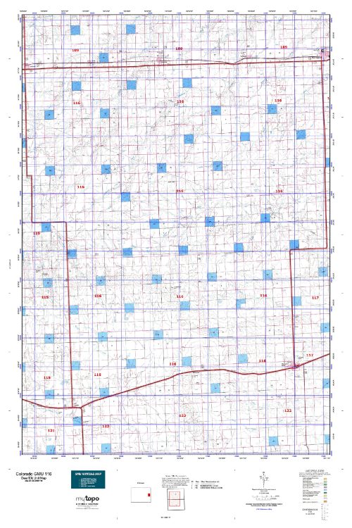
Colorado Unit 116 Hunting Topo Map with Printed Boundaries
Hunters Domain has Colorado Unit 116 hunt area maps that are 1:100,000-scale maps using Bureau of Land Management land status base maps.
Our UNIT 116 maps include:
Colorado public land ownership boundaries
Topographical contour lines
1:100,000 scale for easy viewing
Roads printed
Key terrain features to help you plan your hunt or trip
Hunt area or game management unit 116 (GMU 116) boundary is overlaid on the BLM base map
Easy planning for your upcoming big game hunt by defining roads and routes into the preferred area
Custom maps for Unit 116 are also available (See it all on one map):
Color aerial photo maps: high resolution (you define borders/boundaries)
TOPO maps only where you easily define borders or edges of maps with our online program
Hybrid maps: a unique and detailed aerial photo combined with a USGS topographical maps (user-defined boundaries)
Order your Colorado Unit 116 Map Today!
The actual boundary description/definitions printed below from Colorado Parks and Wildlife hunting regulations brochure could have errors or been amended by the state so always check in their most current printed regulations or the Colorado Parks and Wildlife website to verify these boundaries before hunting as these are for reference only.
Colorado Big Game Unit 116
– Unit 116 Topo/Map Colorado – Game Management Unit (GMU-116).
Game Management Unit (GMU)
BLM Maps:
Reservation Land
US Forest Service Maps:
Reservation land
Click Here to Order Your Color Colorado Unit 116 Hunting Map
Colorado Unit 116 Description
Unit 116 Located in Kit Carson and Cheyenne Counties bounded on the North by I-70; on the East by U.S. 385; on the South by U.S. 40; on the West by Colorado 59.
GMU 116 Elevation: 4,285 to 4,807 feet. Terrain: Consists of level to gently rolling hills. Vegetation: Short-grass prairie with interspersed agricultural crops; some native tall grass mixes throughout the Conservation Reserve Program properties. Weather: Mild and dry. First freeze or snow may occur in mid- Oct. to mid-Nov. Land Status: 100 percent private. Hunter Access: Access is fair to good. Easier to get access for pronghorn than deer. Deer: Deer herds are growing and can be found widely scattered throughout unit. Pronghorn: Primarily in southern half.
Small game: Fair for pheasants in agricultural areas; low densities of scaled quail spread throughout the unit. If hunting waterfowl, focus efforts early in the season. Cottontails are found throughout the unit. Scaled quail in south portion of unit.


Reviews
There are no reviews yet.