Oregon Unit 70 Topo Maps Hunting & Unit Maps 

Oregon Unit 70 Topo Maps Hunting & Unit Maps 

Currently there are 20 peoples are currently looking at this product

Spend $1,000.00 for FREE SHIPPING

Description
Customer Review

Reviews

There are no reviews yet.

Be the first to review “Oregon Unit 70 Topo Maps Hunting & Unit Maps ”

Your email address will not be published. Required fields are marked *

Click Here to View Large Map or Order

Oregon Unit 70 hunting map topo with printed boundaries

HuntersDomain has Oregon unit 70 hunt area maps that are 1:100,000-scale maps using Bureau of Land Management land status base maps.

Our UNIT 70 maps include:

  1. Oregon public land ownership boundaries
  2. Topographical contour lines
  3. 1:100,000 scale for easy viewing
  4. Roads printed
  5. Key terrain features to help you plan your hunt or trip
  6. Hunt area or game management unit 70 (GMU 70) boundary is overlaid on the BLM base map
  7. Easy planning for your upcoming big game hunt by defining roads and routes into the preferred area

Custom maps for unit 70 are also available (See it all on one map):

  1. Color aerial photo maps: high resolution (you define borders/boundaries)
  2. TOPO maps only where you easily define borders or edges of maps with our online program
  3. Hybrid maps: a unique and detailed aerial photo combined with a USGS topographical maps (user-defined boundaries)

Order your unit 70 Oregon topo map today!

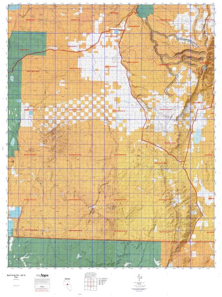
The actual boundary description/definitions printed below from the Oregon Division of Wildlife hunting regulations brochure could have errors or been amended by the state so always check in their most current printed regulations or the Oregon Division of Wildlife website to verify these boundaries before hunting as these are for reference only.

Oregon Big Game

– (Moffat) bounded on N, East, and South by Green River; on West by Utah.

Click Here to Order Unit 70 Topo Map

Unit description

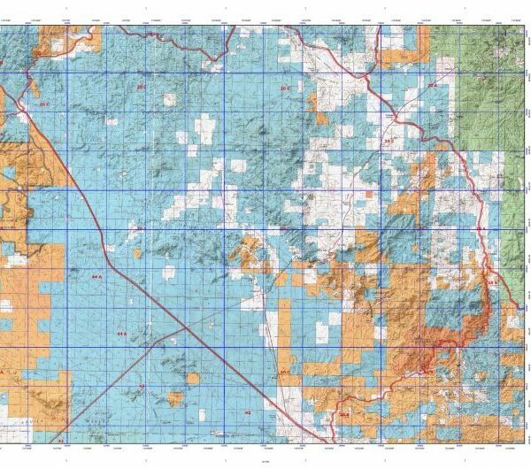
BEATYS BUTTE: 82% of public lands. Beginning at Denio; west on Oregon state line to Fort Bidwell-Warner Valley Road (Lake Company Road 3-14); north on 3-14 to Adel; north on Company Road 3-10 through Plush to Company Road 3-11; east on 3-11 to Hart Refuge and Company Road 3-12; north and east on 3-12 to Hart Refuge headquarters; east on Hart Mount-Frenchglen Road (Lake Company Road 3-12 and Harney Company Road 412) to Catlow Valley Road (Harney Company Road 202); south and east on Catlow Valley Road to Harney Company Road 201, 1 mile north of Fields; south on Company Road 201 through Fields to Denio, point of beginning. Specific hunts do not include Hart Mount NAR. (Maps: Lakeview/Burns Bureau of Land Management)


Shopping cart
Sign in

No account yet?

Start typing to see products you are looking for.
Shop
0 Wishlist
0 items Cart
My account