Nevada Hunting Unit 284 Topo Maps

Nevada Hunting Unit 284 Topo Maps

Currently there are 20 peoples are currently looking at this product

Spend $1,000.00 for FREE SHIPPING

Description
Customer Review

Reviews

There are no reviews yet.

Be the first to review “Nevada Hunting Unit 284 Topo Maps”

Your email address will not be published. Required fields are marked *

Click Here to View Large Map or Order

Nevada Unit 284 hunting map topo with printed boundaries

HuntersDomain has Nevada unit 284 hunt area maps that are 1:100,000-scale maps using Bureau of Land Management land status base maps.

Our UNIT 284 maps include:

  1. Nevada public land ownership boundaries
  2. Topographical contour lines
  3. 1:100,000 scale for easy viewing
  4. Roads printed
  5. Key terrain features to help you plan your hunt or trip
  6. Hunt area or game management unit 284 (GMU 284) boundary is overlaid on the BLM base map
  7. Easy planning for you upcoming big game hunt by defining roads and routes into the preferred area

Custom maps for unit 284 are also available (See it all on one map):

  1. Color aerial photo maps: high resolution (you define borders/boundaries)
  2. TOPO maps only where you easily define borders or edges of maps with our online program
  3. Hybrid maps: a unique and detailed aerial photo combined with a USGS topographical maps (user defined boundaries)

Order your unit 284 Nevada topo map today!

The actual boundary description/definitions printed below from Nevada Division of Wildlife hunting regulations brochure could have errors or been amended by the state so always check in their most current printed regulations or the Nevada Division of Wildlife website to verify these boundaries before hunting as these are for reference only.

Nevada Big Game Unit 284

– Unit 284 Topo/Map Nevada – Game Management Unit (GMU-284).

Game Management Unit (GMU)

BLM Maps:

Reservation Land

US Forest Service Maps:

Reservation land

Click Here to Order Unit 284 Topo Map

Unit description

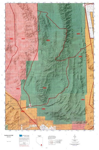
Unit 284: Those portions of Clark and Lincoln counties bounded as follows: Beginning at the Corn Creek Station, thence north along the Alamo Road to the intersection with the road that follows the south shoreline of the Desert Dry Lake approximately 2.8 miles, thence southwesterly to the intersection with Cabin Springs Road, thence southeasterly along the Cabin Springs Road to the county line, thence east to the crest of the Sheep Range, thence south along the crest of the Sheep Range to the Sawmill Canyon Road, thence east along that road to the Mormon Well Road, and thence south and west along that road through Mormon Pass, Peek-a-boo Canyon and Yucca Gap to Corn Creek Station.


Shopping cart
Sign in

No account yet?

Start typing to see products you are looking for.
Shop
0 Wishlist
0 items Cart
My account