Idaho Hunting Unit 60 Island Park Topo Maps 

Idaho Hunting Unit 60 Island Park Topo Maps 

Currently there are 20 peoples are currently looking at this product

Spend $1,000.00 for FREE SHIPPING

Description
Customer Review

Reviews

There are no reviews yet.

Be the first to review “Idaho Hunting Unit 60 Island Park Topo Maps ”

Your email address will not be published. Required fields are marked *

Click Here to View Large Map or Order

Idaho Unit 60 hunting map topo with printed boundaries

HuntersDomain has Idaho unit 60 hunt area maps that are 1:100,000-scale maps using Bureau of Land Management land status base maps.

Our UNIT 60 maps include:

  1. Idaho public land ownership boundaries
  2. Topographical contour lines
  3. 1:100,000 scale for easy viewing
  4. Roads printed
  5. Key terrain features to help you plan your hunt or trip
  6. Hunt area or game management unit 60 (GMU 60) boundary is overlaid on the BLM base map
  7. Easy planning for your upcoming big game hunt by defining roads and routes into the preferred area

Custom maps for unit 60 are also available (See it all on one map):

  1. Color aerial photo maps: high resolution (you define borders/boundaries)
  2. TOPO maps only where you easily define borders or edges of maps with our online program
  3. Hybrid maps: a unique and detailed aerial photo combined with a USGS topographical maps (user-defined boundaries)

Order your unit 60 Idaho topo map today!

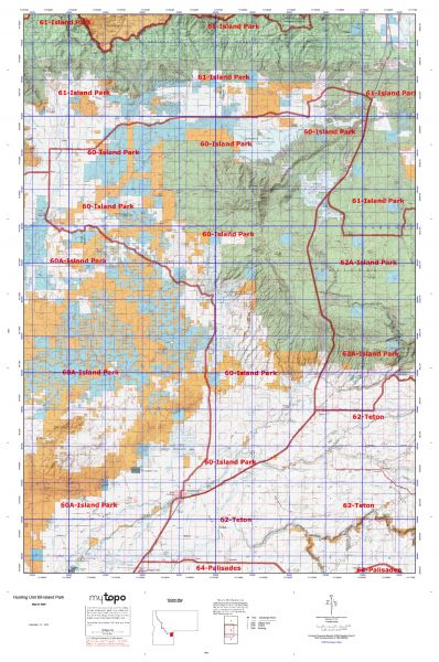
The actual boundary description/definitions printed below from Idaho Division of Wildlife hunting regulations brochure could have errors or been amended by the state so always check in their most current printed regulations or the Idaho Division of Wildlife website to verify these boundaries before hunting as these are for reference only.

Idaho Big Game Unit 60

– Unit 60 Topo/Map Idaho – Game Management Unit (GMU-60).

Game Management Unit (GMU)

BLM Maps:

Reservation Land

US Forest Service Maps:

Reservation land

Click Here to Order Unit 60 Topo Map

Unit description

Unit 60 Island Park: Those portions of Clark and Fremont counties within the following boundary: beginning at Ashton, then north on United States 191-20 to the old (south) Shotgun Valley Road, then west on Shotgun Valley Road to Idmon, then south on the Rexburg-Kilgore Road (Red Road) to the Camas Creek-Jackson Mill Springs Road, then east on Camas Creek-Jackson Mill Springs Road to the Hamilton Hill Road, then southeast on the Hamilton Hill Road to the Sand Creek Road, then southeast on the Sand Creek Road to the old Yellowstone Highway, then east on old Yellowstone Highway to United States 191-20, then north on United States 191-20 to Ashton, the point of beginning. Harriman State Park Wildlife Refuge – closed.


Shopping cart
Sign in

No account yet?

Start typing to see products you are looking for.
Shop
0 Wishlist
0 items Cart
My account