Idaho Hunting Unit 56 Bannock Topo Maps

Idaho Hunting Unit 56 Bannock Topo Maps

Currently there are 20 peoples are currently looking at this product

Spend $1,000.00 for FREE SHIPPING

Description
Customer Review

Reviews

There are no reviews yet.

Be the first to review “Idaho Hunting Unit 56 Bannock Topo Maps”

Your email address will not be published. Required fields are marked *

Click Here to View Large Map or Order

Idaho Unit 56 hunting map topo with printed boundaries

HuntersDomain has Idaho unit 56 hunt area maps that are 1:100,000-scale maps using Bureau of Land Management land status base maps.

Our UNIT 56 maps include:

  1. Idaho public land ownership boundaries
  2. Topographical contour lines
  3. 1:100,000 scale for easy viewing
  4. Roads printed
  5. Key terrain features to help you plan your hunt or trip
  6. Hunt area or game management unit 56 (GMU 56) boundary is overlaid on the BLM base map
  7. Easy planning for your upcoming big game hunt by defining roads and routes into the preferred area

Custom maps for unit 56 are also available (See it all on one map):

  1. Color aerial photo maps: high resolution (you define borders/boundaries)
  2. TOPO maps only where you easily define borders or edges of maps with our online program
  3. Hybrid maps: a unique and detailed aerial photo combined withe USGS topographical maps (user-defined boundaries)

Order your unit 56 Idaho topo map today!

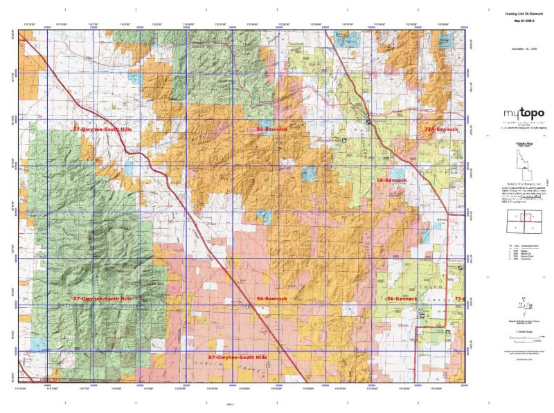
The actual boundary description/definitions printed below from Idaho Division of Wildlife hunting regulations brochure could have errors or been amended by the state so always check in their most current printed regulations or the Idaho Division of Wildlife website to verify these boundaries before hunting as these are for reference only.

Idaho Big Game Unit 56

– Unit 56 Topo/Map Idaho – Game Management Unit (GMU-56).

Game Management Unit (GMU)

BLM Maps:

Reservation Land

US Forest Service Maps:

Reservation land

Click Here to Order Unit 56 Topo Map

Unit description

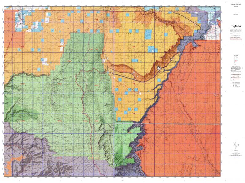
Unit 56 Bannock: Those portions of Cassia, Oneida, and Power counties within the following boundary: beginning at the Yale Road-State Highway 81 junction, then northeast on Yale Road over Interstate 84 to Interstate 86, then east on Interstate 86 to State Highway 37, then south on State Highway 37 to Holbrook, then south on the Holbrook-Stone Road to the Idaho-Utah State line, then west on the state line to Interstate 84, then northwest on Interstate 84 to the Malta-Sublett Road, then west on Malta-Sublett Road to its junction with State Highway 81, then north on State Highway 81 to the point of beginning.


Shopping cart
Sign in

No account yet?

Start typing to see products you are looking for.
Shop
0 Wishlist
0 items Cart
My account