Click Here to View Large Map or Order
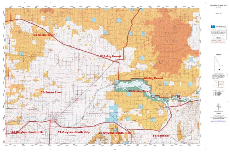
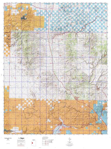
Idaho Unit 53 hunting map topo with printed boundaries
HuntersDomain has Idaho unit 53 hunt area maps that are 1:100,000-scale maps using Bureau of Land Management land status base maps.
Our UNIT 53 maps include:
- Idaho public land ownership boundaries
- Topographical contour lines
- 1:100,000 scale for easy viewing
- Roads printed
- Key terrain features to help you plan your hunt or trip
- Hunt area or game management unit 53 (GMU 53) boundary is overlaid on the BLM base map
- Easy planning for your upcoming big game hunt by defining roads and routes into the preferred area
Custom maps for unit 53 are also available (See it all on one map):
- Color aerial photo maps: high resolution (you define borders/boundaries)
- TOPO maps only where you easily define borders or edges of maps with our online program
- Hybrid maps: a unique and detailed aerial photo combined with a USGS topographical maps (user-defined boundaries)
Order your unit 53 Idaho topo map today!
The actual boundary description/definitions printed below from Idaho Division of Wildlife hunting regulations brochure could have errors or been amended by the state so always check in their most current printed regulations or the Idaho Division of Wildlife website to verify these boundaries before hunting as these are for reference only.
Idaho Big Game Unit 53
– Unit 53 Topo/Map Idaho – Game Management Unit (GMU-53).
Game Management Unit (GMU)
BLM Maps:
Reservation Land
US Forest Service Maps:
Reservation land
Click Here to Order Unit 53 Topo Map
Unit description
Unit 53 Snake River: Those portions of Blaine, Cassia, Gooding, Jerome, Lincoln, Minidoka, Power, and Twin Falls counties within the following boundary: beginning at Twin Falls, then west and north on United States 30 to the Snake River, then down the Snake River to the Malad River, then up the Malad River to United States 30, then northwest on United States 30 to Bliss, then east on United States 26 to Shoshone, then southeast on State Highway 24 to Minidoka, then east on the Union Pacific railroad tracks to the Minidoka-Blaine County line, then south along the Minidoka- Blaine County line to the Minidoka National Wildlife Refuge, then southeast along the refuge boundary to the Cassia- Power County line, then south along the Cassia-Power County line to Interstate 86 near Raft River, then west on Interstate 86 to Yale Road, then southwest on Yale Road over Interstate 84 to State Highway 81, then west on State Highway 81 to Burley, then west on United States 30 to Twin Falls, the point of beginning. Minidoka National Wildlife Refuge – closed.


Reviews
There are no reviews yet.