Click Here to View Large Map or to Purchase
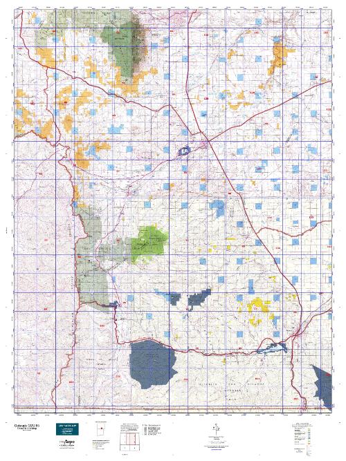
Colorado Unit 85 Hunting Topo Map with Printed Boundaries
Hunters Domain has Colorado Unit 85 hunt area maps that are 1:100,000-scale maps using Bureau of Land Management land status base maps.
Our UNIT 85 maps include:
Colorado public land ownership boundaries
Topographical contour lines
1:100,000 scale for easy viewing
Roads printed
Key terrain features to help you plan your hunt or trip
Hunt area or game management unit 85 (GMU 85) boundary is overlaid on the BLM base map
Easy planning for your upcoming big game hunt by defining roads and routes into the preferred area
Custom maps for Unit 85 are also available (See it all on one map):
Color aerial photo maps: high resolution (you define borders/boundaries)
TOPO maps only where you easily define borders or edges of maps with our online program
Hybrid maps: a unique and detailed aerial photo combined with a USGS topographical maps (user-defined boundaries)
Order your Colorado Unit 85 Map Today!
The actual boundary description/definitions printed below from Colorado Parks and Wildlife hunting regulations brochure could have errors or been amended by the state so always check in their most current printed regulations or the Colorado Parks and Wildlife website to verify these boundaries before hunting as these are for reference only.
Colorado Big Game Unit 85
– Unit 85 Topo/Map Colorado – Game Management Unit (GMU-85).
Game Management Unit (GMU)
BLM Maps:
Reservation Land
US Forest Service Maps:
Reservation land
Click Here to Order Your Color Colorado Unit 85 Hunting Map
Colorado Unit 85 Description
Unit 85 Located in Huerfano and Las Animas Counties bounded on the North by Colorado 69; on the East by I-25; on the South by Colo. 12 and North and West forks of Purgatoire River; on the West by Sangre de Cristo divide and Huerfano CRs 570, 572 (Pass Creek Rd.) & 555 (Muddy Creek Rd.).
GMU 85 Elevation: 13,518 feet on Trinchera Peak to 6,025 feet near Trinidad. Terrain: Flat valley bottoms to moderately steep foothills to steep mountains. Vegetation: Grassland to piñons & junipers to pine-oak to spruce-fir to alpine meadows. Weather: Variable; expect first freeze or snow from mid-September to mid-October. Land status: 75 percent private. Hunter Access: Good to public land; reasonable to private land. Limited licenses available
for Twin Peaks RFW. Deer: Generally, south half of unit is better than north half. In later seasons, deer tend to
concentrate in Apishapa drainage, Jarosa, Burro, Chicosa, and Road Canyon. Canyon del Agua is also a good area. Elk: Better elk hunting is in the Silver Mountain area, west and southwest of La Veta. Good population in Apishapa River drainage but is on private land. Earlier season areas include Cross Mountain and Huerfano River drainage. Later seasons areas include Jarosa Canyon, Santa Clare Creek and Abeta Creek. See brochure for special season structures.
Pronghorn: Fair antelope hunting in valley bottom along I-25 but entirely private and by draw only (rifle). Other areas include along Colo. Hwy. 69 south and east of Badito.


Reviews
There are no reviews yet.