Click Here to View Large Map or to Purchase
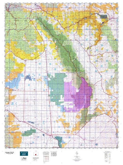
Colorado Unit 82 Hunting Topo Map with Printed Boundaries
Hunters Domain has Colorado Unit 82 hunt area maps that are 1:100,000-scale maps using Bureau of Land Management land status base maps.
Our UNIT 82 maps include:
Colorado public land ownership boundaries
Topographical contour lines
1:100,000 scale for easy viewing
Roads printed
Key terrain features to help you plan your hunt or trip
Hunt area or game management unit 82 (GMU 82) boundary is overlaid on the BLM base map
Easy planning for your upcoming big game hunt by defining roads and routes into the preferred area
Custom maps for Unit 82 are also available (See it all on one map):
Color aerial photo maps: high resolution (you define borders/boundaries)
TOPO maps only where you easily define borders or edges of maps with our online program
Hybrid maps: a unique and detailed aerial photo combined with a USGS topographical maps (user-defined boundaries)
Order your Colorado Unit 82 Map Today!
The actual boundary description/definitions printed below from Colorado Parks and Wildlife hunting regulations brochure could have errors or been amended by the state so always check in their most current printed regulations or the Colorado Parks and Wildlife website to verify these boundaries before hunting as these are for reference only.
Colorado Big Game Unit 82
– Unit 82 Topo/Map Colorado – Game Management Unit (GMU-82).
Game Management Unit (GMU)
BLM Maps:
Reservation Land
US Forest Service Maps:
Reservation land
Click Here to Order Your Colorado Unit 82 Topo Map
Colorado Unit 82 Description
Unit 82 San Luis Valley Area: Alamaso and Saguache Counties bounded on the North by Poncha Pass; on North and East by Rio Grande-Arkansas River divide; on South by Alamosa-Costilla Co. line and U.S. 160; on the West by Colorado HWY 17 and U.S. 285.
The San Luis Valley is a vast 8,000-square-mile area that provides a wide variety of terrain at elevations that range from 7,500 feet to 14,000 feet. The rugged Sangre de Cristo Mountains define the valley’s east side. The middle of the valley is flat farm land that is privately owned. The Rio Grande and the Conejos River provide long riparian areas that cut through high-elevation alpine forests to lower elevation cottonwood and willow stands. The west is bordered by the Rio Grande National Forest and the San Juan mountain range.
Throughout the area, access varies from moderate to very difficult. Hunting can be good for those willing to go into tough terrain. Hunting is also challenging because animals in many areas can move quickly to large areas of private or federal refuge land.


Reviews
There are no reviews yet.