Click Here to View Large Map or to Purchase
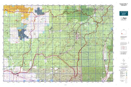
Colorado Unit 71 Hunting Topo Map with Printed Boundaries
Hunters Domain has Colorado Unit 71 hunt area maps that are 1:100,000-scale maps using Bureau of Land Management land status base maps.
Our UNIT 71 maps include:
Colorado public land ownership boundaries
Topographical contour lines
1:100,000 scale for easy viewing
Roads printed
Key terrain features to help you plan your hunt or trip
Hunt area or game management unit 71 (GMU 71) boundary is overlaid on the BLM base map
Easy planning for your upcoming big game hunt by defining roads and routes into the preferred area
Custom maps for Unit 71 are also available (See it all on one map):
Color aerial photo maps: high resolution (you define borders/boundaries)
TOPO maps only where you easily define borders or edges of maps with our online program
Hybrid maps: a unique and detailed aerial photo combined with a USGS topographical maps (user-defined boundaries)
Order your Colorado Unit 71 Map Today!
The actual boundary description/definitions printed below from Colorado Parks and Wildlife hunting regulations brochure could have errors or been amended by the state so always check in their most current printed regulations or the Colorado Parks and Wildlife website to verify these boundaries before hunting as these are for reference only.
Colorado Big Game Unit 71
– Unit 71 Topo/Map Colorado – Game Management Unit (GMU-71).
Game Management Unit (GMU)
BLM Maps:
Reservation Land
US Forest Service Maps:
Reservation land
Click Here to Order Your Colorado Unit 71 Topo Map
Colorado Unit 71 Description
Unit 71 Dolores – Dry Creek Region: Dolores and Montezuma Counties bounded on the North by Disappointment Creek and Dolores-San Miguel County line; on the East by Dolores-San Juan County line, Montezuma-La Plata County line and Bear Creek; on the South by Colorado Hwy 145; on the West by USFS 526 (Dolores-Norwood Rd.).
This region covers a 2,800-square-mile landscape from the west side of the Uncompahgre Plateau to the Utah state line and south to the New Mexico state line. Habitat throughout these GMUs is favorable for big game. With altitudes from 5,000 feet to more than 12,000 feet, the vegetation ranges from desert shrubs to alpine tundra. Weather can change quickly, so be prepared for all conditions. There is good vehicle access in these areas; consequently, hunting pressure can be heavy in areas of easily accessible public land. An exception is the Lizard Head Wilderness Area, GMU 71, which is accessible by foot and horseback only. Also be aware of private land in the northern sections of GMU 71.


Reviews
There are no reviews yet.