Click Here to View Large Map or to Purchase
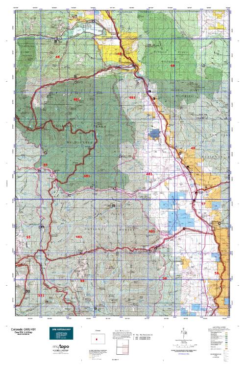
Colorado Unit 481 Hunting Topo Map with Printed Boundaries
Hunters Domain has Colorado Unit 481 hunt area maps that are 1:100,000-scale maps using Bureau of Land Management land status base maps.
Our UNIT 481 maps include:
Colorado public land ownership boundaries
Topographical contour lines
1:100,000 scale for easy viewing
Roads printed
Key terrain features to help you plan your hunt or trip
Hunt area or game management unit 481 (GMU 481) boundary is overlaid on the BLM base map
Easy planning for your upcoming big game hunt by defining roads and routes into the preferred area
Custom maps for Unit 481 are also available (See it all on one map):
Color aerial photo maps: high resolution (you define borders/boundaries)
TOPO maps only where you easily define borders or edges of maps with our online program
Hybrid maps: a unique and detailed aerial photo combined with a USGS topographical maps (user-defined boundaries)
Order your Colorado Unit 481 Map Today!
The actual boundary description/definitions printed below from Colorado Parks and Wildlife hunting regulations brochure could have errors or been amended by the state so always check in their most current printed regulations or the Colorado Parks and Wildlife website to verify these boundaries before hunting as these are for reference only.
Colorado Big Game Unit 481
– Unit 481 Topo/Map Colorado – Game Management Unit (GMU-481).
Game Management Unit (GMU)
BLM Maps:
Reservation Land
US Forest Service Maps:
Reservation land
Click Here to Order Your Color Colorado Unit 481 Hunting Map
Colorado Unit 481 Description
Unit 481 Located in Chaffee County bounded on the North by South Fork of Clear Creek and Clear Creek; on the East by the Arkansas River; on the South by Chalk Creek and Tincup Pass Rd. from St. Elmo; on the West by the Continental Divide.
GMU 481 Elevation: 14,420 on Mt. Harvard to 7,710 near Nathrop. Terrain: Broad, level valley bottom, changing rapidly to steep, rough mountains. Vegetation: Grassy hay meadows to aspens and ponderosa to spruce and fir to alpine tundra. Weather: Extremely variable; first freeze or snow may occur in early September. Land Status: Approximately 80 percent public and 20 percent private. Hunter Access: Fair. Public roads, trails provide limited access to public lands. Considerable wilderness with trails that are foot or horseback only. Deer: Deer are found throughout the unit, but better deer hunting at lower elevations. In later seasons, deer will move down toward the town of Buena Vista and along Hwy 24. Elk: Look for elk throughout the unit primarily in the 8,000 to 10,000-foot elevation range. Steep, rough country. Elk above timberline in the areas around Frenchman Creek, east face of Mt. Princeton and the Heckendorf State Wildlife Area, which is below timberline. First season finds elk anywhere from 7500’ to above timberline. The amount of snow will determine where the elk are. Follow the snow line down as snow progresses.


Reviews
There are no reviews yet.