Click Here to View Large Map or to Purchase
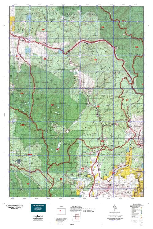
Colorado Unit 45 Hunting Topo Map with Printed Boundaries
Hunters Domain has Colorado Unit 45 hunt area maps that are 1:100,000-scale maps using Bureau of Land Management land status base maps.
Our UNIT 45 maps include:
Colorado public land ownership boundaries
Topographical contour lines
1:100,000 scale for easy viewing
Roads printed
Key terrain features to help you plan your hunt or trip
Hunt area or game management unit 45 (GMU 45) boundary is overlaid on the BLM base map
Easy planning for your upcoming big game hunt by defining roads and routes into the preferred area
Custom maps for Unit 45 are also available (See it all on one map):
Color aerial photo maps: high resolution (you define borders/boundaries)
TOPO maps only where you easily define borders or edges of maps with our online program
Hybrid maps: a unique and detailed aerial photo combined with a USGS topographical maps (user-defined boundaries)
Order your Colorado Unit 45 Map Today!
The actual boundary description/definitions printed below from Colorado Parks and Wildlife hunting regulations brochure could have errors or been amended by the state so always check in their most current printed regulations or the Colorado Parks and Wildlife website to verify these boundaries before hunting as these are for reference only.
Colorado Big Game Unit 45
– Unit 45 Topo/Map Colorado – Game Management Unit (GMU-45).
Game Management Unit (GMU)
BLM Maps:
Reservation Land
US Forest Service Maps:
Reservation land
Click Here to Order Your Color Colorado Unit 45 Topo Map
Colorado Unit 45 Description
Unit 45 Located in Pitkin and Eagle Counties bounded on the North by the Eagle River from East Lake Creek to Dowd
Junction, I-70 from Dowd Junction to Eagle River-Tenmile Creek divide; on the East by Eagle River-Tenmile Creek divide; on the South by Continental Divide; on the West by divide between Chance Creek- North Fork Fryingpan-Cunningham Creek drainages and East Lake Creek.
GMU 45 These units are bordered by the Colorado River, the Gore Range, the Red Table Mountains and the Continental Divide. Elevation climbs from 6,000’ with sage and pinyon to over 14,000’ with alpine vegetation starting at 10,500’. Weather varies widely with heavy high country snow. Motorized travel restricted to designated routes. Deer herds are scattered from 6,500’ to timberline, moving down to the lower elevation pinyon-juniper areas as heavy snow arrives. Over 18” of snow will move the deer. Hunt the aspen, open parks and shrublands. After the first heavy snow, most GMU 45 deer will move into GMU 36. Elk are scattered from about 7,000’ to above timberline. As hunting pressure increases, they seek the deeper canyons and dark timber areas way from roads. Concentrating on the large stands of dark timber and the larger wilderness areas will increase your chance of finding a big bull on public lands.


Reviews
There are no reviews yet.