Click Here to View Large Map or to Purchase
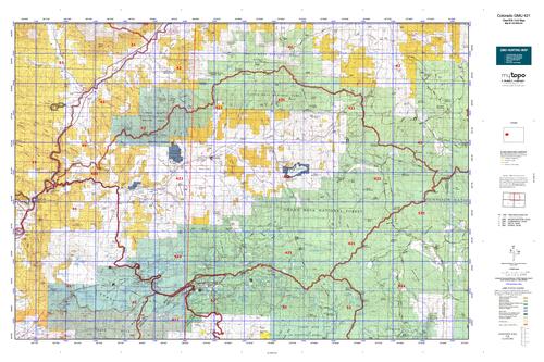
Colorado Unit 421 Hunting Topo Map with Printed Boundaries
Hunters Domain has Colorado Unit 421 hunt area maps that are 1:100,000-scale maps using Bureau of Land Management land status base maps.
Our UNIT 421 maps include:
Colorado public land ownership boundaries
Topographical contour lines
1:100,000 scale for easy viewing
Roads printed
Key terrain features to help you plan your hunt or trip
Hunt area or game management unit 421 (GMU 421) boundary is overlaid on the BLM base map
Easy planning for your upcoming big game hunt by defining roads and routes into the preferred area
Custom maps for Unit 421 are also available (See it all on one map):
Color aerial photo maps: high resolution (you define borders/boundaries)
TOPO maps only where you easily define borders or edges of maps with our online program
Hybrid maps: a unique and detailed aerial photo combined with a USGS topographical maps (user-defined boundaries)
Order your Colorado Unit 421 Map Today!
The actual boundary description/definitions printed below from Colorado Parks and Wildlife hunting regulations brochure could have errors or been amended by the state so always check in their most current printed regulations or the Colorado Parks and Wildlife website to verify these boundaries before hunting as these are for reference only.
Colorado Big Game Unit 421
– Unit 421 Topo/Map Colorado – Game Management Unit (GMU-421).
Game Management Unit (GMU)
BLM Maps:
Reservation Land
US Forest Service Maps:
Reservation land
Click Here to Order Your Color Colorado Unit 421 Hunting Map
Colorado Unit 421 Description
Unit 421 Located in Mesa and Garfield Counties bounded on the North by the Colorado River-Plateau Creek divide; on the East by Divide Creek-Buzzard Creek divide; on the South by Mesa-Delta Co. line; on the West by Colorado 65.
GMU 421 Grand Mesa terrain ranges from high elevation (11,000’) spruce/fir forests to low elevation (4,800’) pinyon-juniper woodlands. Weather can be rainy or snowy, then warm up and dry out the following day. Roads can become very muddy and 4WD is recommended. Hunters should be prepared to spend time on foot or horseback. Much of the area is public land. Overall, the hunting pressure is heavy. Deer are found on forest lands and higher elevation private lands during Oct. The resident deer stay in lower agricultural areas year round. The migrating deer herd begins to move off the forest to lower elevations in mid-Nov, often to BLM lands. The best deer hunting is at mid elevations (8,500-9,500’), with more buck opportunities in the later seasons. The Battlements can be good in late seasons, but the terrain is rugged. The open country offers good opportunities for those who get out on foot or horseback. The elk herd is well distributed with good hunting success expected. Elk are scattered throughout the forest and on private lands. Most elk stay at higher elevations (8500- 10,000’) in thick timber and oakbrush. There is no migration during the season, movement to the more remote areas is in response to hunting pressure. They will seek classic cover – the heavily wooded, north-facing slopes near water. You will need to get away from the roads. There are lots of legal bulls as the area is managed for quantity of bulls rather than trophy status. Hence, trophy bulls are present but relatively rare.


Reviews
There are no reviews yet.