Click Here to View Large Map or to Purchase
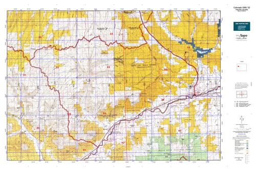
Colorado Unit 32 Hunting Topo Map with Printed Boundaries
Hunters Domain has Colorado Unit 32 hunt area maps that are 1:100,000-scale maps using Bureau of Land Management land status base maps.
Our UNIT 32 maps include:
Colorado public land ownership boundaries
Topographical contour lines
1:100,000 scale for easy viewing
Roads printed
Key terrain features to help you plan your hunt or trip
Hunt area or game management unit 32 (GMU 32) boundary is overlaid on the BLM base map
Easy planning for your upcoming big game hunt by defining roads and routes into the preferred area
Custom maps for Unit 32 are also available (See it all on one map):
Color aerial photo maps: high resolution (you define borders/boundaries)
TOPO maps only where you easily define borders or edges of maps with our online program
Hybrid maps: a unique and detailed aerial photo combined with a USGS topographical maps (user-defined boundaries)
Order your Colorado Unit 32 Map Today!
The actual boundary description/definitions printed below from Colorado Parks and Wildlife hunting regulations brochure could have errors or been amended by the state so always check in their most current printed regulations or the Colorado Parks and Wildlife website to verify these boundaries before hunting as these are for reference only.
Colorado Big Game Unit 32
– Unit 32 Topo/Map Colorado – Game Management Unit (GMU-32).
Game Management Unit (GMU)
BLM Maps:
Reservation Land
US Forest Service Maps:
Reservation land
Click Here to Order Your Color Colorado Unit 32 Topo Map
Colorado Unit 32 Description
Unit 32 Located in Garfield County bounded on the North by Parachute Creek-Piceance Creek divide; on
the East by Colorado 13/789; on the South by the Colorado River; on the West by Kelly Gulch and Roan Creek-Parachute Creek divide.
GMU 32 Pinyon-juniper, with pockets of sagebrush, cover most of the areas at lower elevations. Higher elevations are characterized by sagebrush interspersed with aspen stands and some dark timber. Terrain varies from rolling sagebrush to steep-sided canyons. Some areas are steep & rugged, especially in southern portion. Rains bring muddy roads. High elevation snows make roads impassible without chains. 75% of area is BLM land. There are remote hunting areas accessible by foot, horseback or ATV. Get maps and study BLM access points. Weather is generally mild. Hunting ranges from fair to good in the Bookcliffs and Piceance units. Deer are well-distributed in the northern portion after mid October. Concentrate on higher elevations in early seasons. If the weather is dry, you’ll need to do a lot of walking and looking. Good snows will move the herds to lower elevations to the north and to the south. Hunt high early, low later. Cathedral Rim has some big bucks, but tough terrain. Little Hills and Dry Fork of Piceance is better late. Good cow hunting opportunities. The best hunting is in remote areas, mostly at high elevations, where the elk tend to hold up in pockets of green timber and aspen. Check out the Texas Mountain area and Rat Hole Ridge. Hunting pressure will push some bulls into the large expanses of pinyon-juniper. If snow and hunting pressure are sufficient, some elk will move into the Little Hills and Dry Fork area of Piceance later in the seasons. Most of the GMU 32 elk move into GMU 22 for late winter.


Reviews
There are no reviews yet.