Click Here to View Large Map or to Purchase
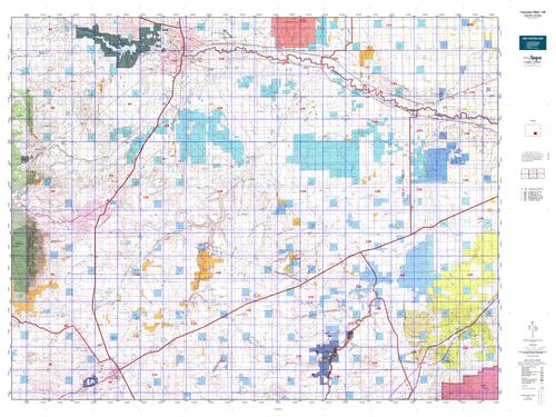
Colorado Unit 128 Hunting Topo Map with Printed Boundaries
Hunters Domain has Colorado Unit 128 hunt area maps that are 1:100,000-scale maps using Bureau of Land Management land status base maps.
Our UNIT 128 maps include:
Colorado public land ownership boundaries
Topographical contour lines
1:100,000 scale for easy viewing
Roads printed
Key terrain features to help you plan your hunt or trip
Hunt area or game management unit 128 (GMU 128) boundary is overlaid on the BLM base map
Easy planning for your upcoming big game hunt by defining roads and routes into the preferred area
Custom maps for Unit 128 are also available (See it all on one map):
Color aerial photo maps: high resolution (you define borders/boundaries)
TOPO maps only where you easily define borders or edges of maps with our online program
Hybrid maps: a unique and detailed aerial photo combined with a USGS topographical maps (user-defined boundaries)
Order your Colorado Unit 128 Map Today!
The actual boundary description/definitions printed below from Colorado Parks and Wildlife hunting regulations brochure could have errors or been amended by the state so always check in their most current printed regulations or the Colorado Parks and Wildlife website to verify these boundaries before hunting as these are for reference only.
Colorado Big Game Unit 128
– Unit 128 Topo/Map Colorado – Game Management Unit (GMU-128).
Game Management Unit (GMU)
BLM Maps:
Reservation Land
US Forest Service Maps:
Reservation land
Click Here to Order Your Color Colorado Unit 128 Hunting Map
Colorado Unit 128 Description
Unit 128 Located in Huerfano, Los Animos, Otero and Pueblo Counties bounded on the North by the Arkansas River; on the East by Colorado 167; on the South by Colorado hwy 10; on the West by I-25.
GMU 128 Elevation: 6,185 to 4,341 feet. Terrain: Flat to gently rolling with steep irregular plateaus, canyons.
Vegetation: Shortgrass prairie with limited farmland, pinon/juniper/shrub, riparian cottonwood. Weather: Mild with first freeze and snow possible early October. Land Status: 90 percent private. GMU 128 contains a ~6,000 acre BLM tract called Chucaras Canyon. It also contains a STL called the St. Charles property. There is also a small game access property called the Vold property. Hunter Access: Good for pronghorn, fair for deer. Deer: Along the Arkansas River, Huerfano River and in the Cedarwood area. Pronghorn: Throughout the unit.


Reviews
There are no reviews yet.