Arizona Unit 9 Topo Maps Hunting & Unit Maps

Arizona Unit 9 Topo Maps Hunting & Unit Maps

Currently there are 20 peoples are currently looking at this product

Spend $1,000.00 for FREE SHIPPING

Description
Customer Review

Reviews

There are no reviews yet.

Be the first to review “Arizona Unit 9 Topo Maps Hunting & Unit Maps”

Your email address will not be published. Required fields are marked *

Click Here to View Large Map or Order

Arizona Unit 9 hunting map topo with printed boundaries

HuntersDomain has Arizona unit 9 hunt area maps that are 1:100,000-scale maps using Bureau of Land Management land status base maps.

Our UNIT 9 maps include:

  1. Arizona public land ownership boundaries
  2. Topographical contour lines
  3. 1:100,000 scale for easy viewing
  4. Roads printed
  5. Key terrain features to help you plan your hunt or trip
  6. Hunt area or game management unit 9 (GMU 9) boundary is overlaid on the BLM base map
  7. Easy planning for your upcoming big game hunt by defining roads and routes into the preferred area

Custom maps for unit 9 are also available (See it all on one map):

  1. Color aerial photo maps: high resolution (you define borders/boundaries)
  2. TOPO maps only where you easily define borders or edges of maps with our online program
  3. Hybrid maps: a unique and detailed aerial photo combined withe USGS topographical maps (user-defined boundaries)

Order your unit 9 Arizona topo map today!

The actual boundary description/definitions printed below from the Arizona Division of Wildlife hunting regulations brochure could have errors or been amended by the state so always check in their most current printed regulations or the Arizona Division of Wildlife website to verify these boundaries before hunting as these are for reference only.

Arizona Big Game

Click Here to Order Unit 9 Topo Map

Unit description

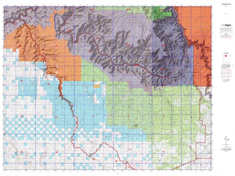
Unit 9 Beginning where Cataract Creek enters the Havasupai Reservation; easterly and northerly along the Havasupai Reservation boundary to Grand Canyon National Park; easterly along the Grand Canyon National Park boundary to the Navajo Indian Reservation boundary; southerly along the reservation boundary to the Four Corners Gas Line; southwesterly along the Four Corners Gas Line to United States Highway 180; westerly along United States Highway 180 to Arizona Highway 64; south along Arizona Highway 64 to Airpark Road; west and north along Airpark Road to the Valle-Cataract Creek Road; westerly along the Valle-Cataract Creek Road to Cataract Creek at Island Tank; northwesterly along Cataract Creek to the Havasupai Reservation Boundary.


Shopping cart
Sign in

No account yet?

Start typing to see products you are looking for.
Shop
0 Wishlist
0 items Cart
My account