Description
Arizona Unit 34 A hunting map topo with printed boundaries
Hunters Domain has Arizona unit 34 A hunting area maps that are 1:100,000-scale maps using Bureau of Land Management land status base maps.
Our UNIT 34 A maps include:
- Arizona public land ownership boundaries
- Topographical contour lines
- 1:100,000 scale for easy viewing
- Roads printed
- Key terrain features to help you plan your hunt or trip
- Hunt area or game management unit 34 A (GMU 34 A) boundary is overlaid on the BLM base map
- Easy planning for your upcoming big game hunt by defining roads and routes into the preferred area
Custom maps for unit 34 A are also available (See it all on one map):
- Color aerial photo maps: high resolution (you define borders/boundaries)
- TOPO maps only where you easily define borders or edges of maps with our online program
- Hybrid maps: a unique and detailed aerial photo combined withe USGS topographical maps (user-defined boundaries)
Order your unit 34 A Arizona topo map today!
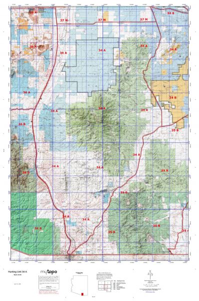
The actual boundary description/definitions printed below from the Arizona Division of Wildlife hunting regulations brochure could have errors or been amended by the state so always check in their most current printed regulations or the Arizona Division of Wildlife website to verify these boundaries before hunting as these are for reference only.
Arizona Big Game
Unit description
Unit 34 A Beginning in Nogales at Interstate-19 and Grand Avenue(United States Highway 89); northeast on Grand Avenue (United States Highway 89) to Arizona Highway 82; northeast on Arizona Highway 82 to Arizona Highway 83; northerly on Arizona Highway 83 to the Sahuarita road alignment; west along the Sahuarita road alignment to Interstate-19 Exit 75; south on Interstate-19 to Grand Avenue (United States Highway 89).