Oregon Unit 65 Topo Maps Hunting & Unit Maps 

Oregon Unit 65 Topo Maps Hunting & Unit Maps 

Currently there are 20 peoples are currently looking at this product

Spend $1,000.00 for FREE SHIPPING

Description
Customer Review

Reviews

There are no reviews yet.

Be the first to review “Oregon Unit 65 Topo Maps Hunting & Unit Maps ”

Your email address will not be published. Required fields are marked *

Click Here to View Large Map or Order

Oregon Unit 65 hunting map topo with printed boundaries

HuntersDomain has Oregon unit 65 hunt area maps that are 1:100,000-scale maps using Bureau of Land Management land status base maps.

Our UNIT 65 maps include:

  1. Oregon public land ownership boundaries
  2. Topographical contour lines
  3. 1:100,000 scale for easy viewing
  4. Roads printed
  5. Key terrain features to help you plan your hunt or trip
  6. Hunt area or game management unit 65 (GMU 65) boundary is overlaid on the BLM base map
  7. Easy planning for your upcoming big game hunt by defining roads and routes into the preferred area

Custom maps for unit 65 are also available (See it all on one map):

  1. Color aerial photo maps: high resolution (you define borders/boundaries)
  2. TOPO maps only where you easily define borders or edges of maps with our online program
  3. Hybrid maps: a unique and detailed aerial photo combined with a USGS topographical maps (user-defined boundaries)

Order your unit 65 Oregon topo map today!

The actual boundary description/definitions printed below from the Oregon Division of Wildlife hunting regulations brochure could have errors or been amended by the state so always check in their most current printed regulations or the Oregon Division of Wildlife website to verify these boundaries before hunting as these are for reference only.

Oregon Big Game

– (Moffat) bounded on N, East, and South by Green River; on West by Utah.

Click Here to Order Unit 65 Topo Map

Unit description

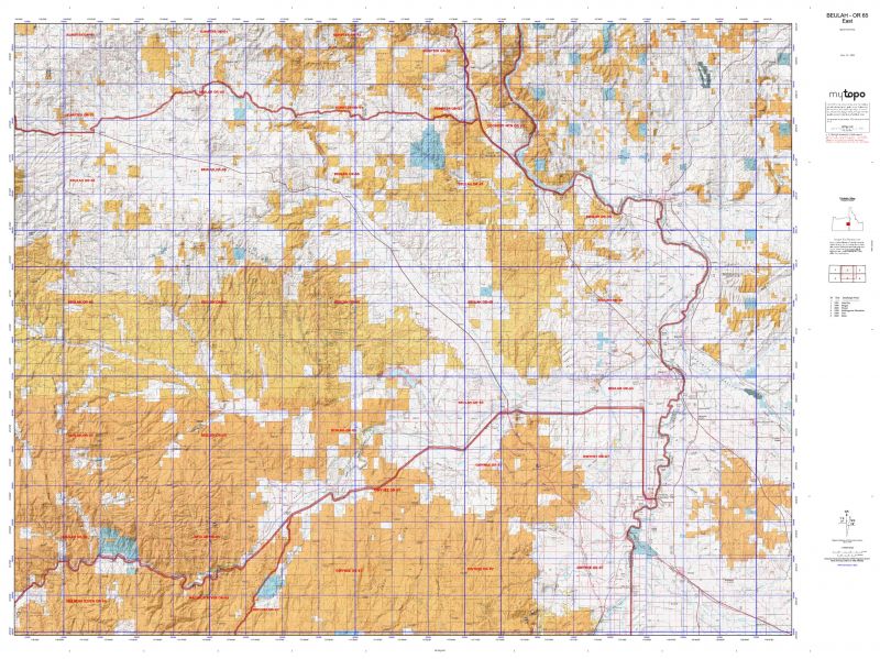
BEULAH 57% of public lands. Beginning at Vale; southwest on United States Highway 20 to Drewsey-Prairie City Road near Drewsey; northwestern Drewsey-Prairie City Road and Forest Road 1663 to the junction with Forest Road 14 near Antelope Mount; northwest on Forest Road 14 and Forest Road 16 to Summilet Prairie; north on Company Road 62 to United States Highway 26; east on Highway 26 to Ironside; east on Malheur Reservoir Road to Interstate-84; southeast on Interstate-84 to Birch Circle near Farewell Bend; east on Birch Circle to Snake River; southeast along Snake River to Nyssa; north on Highway 201 to Cairo Junction; and west on United States Highway 20 to Vale, point of beginning. (Maps: Vale/Burns Bureau of Land Management, Malheur/Wallowa-Whitman National Forest)


Shopping cart
Sign in

No account yet?

Start typing to see products you are looking for.
Shop
0 Wishlist
0 items Cart
My account