Oregon Unit 35 Topo Maps Hunting & Unit Maps 

Oregon Unit 35 Topo Maps Hunting & Unit Maps 

Currently there are 20 peoples are currently looking at this product

Spend $1,000.00 for FREE SHIPPING

Description
Customer Review

Reviews

There are no reviews yet.

Be the first to review “Oregon Unit 35 Topo Maps Hunting & Unit Maps ”

Your email address will not be published. Required fields are marked *

Click Here to View Large Map or Order

Oregon Unit 35 hunting map topo with printed boundaries

HuntersDomain has Oregon unit 35 hunt area maps that are 1:100,000-scale maps using Bureau of Land Management land status base maps.

Our UNIT 35 maps include:

  1. Oregon public land ownership boundaries
  2. Topographical contour lines
  3. 1:100,000 scale for easy viewing
  4. Roads printed
  5. Key terrain features to help you plan your hunt or trip
  6. Hunt area or game management unit 35 (GMU 35) boundary is overlaid on the BLM base map
  7. Easy planning for your upcoming big game hunt by defining roads and routes into the preferred area

Custom maps for unit 35 are also available (See it all on one map):

  1. Color aerial photo maps: high resolution (you define borders/boundaries)
  2. TOPO maps only where you easily define borders or edges of maps with our online program
  3. Hybrid maps: a unique and detailed aerial photo combined with a USGS topographical maps (user-defined boundaries)

Order your unit 35 Oregon topo map today!

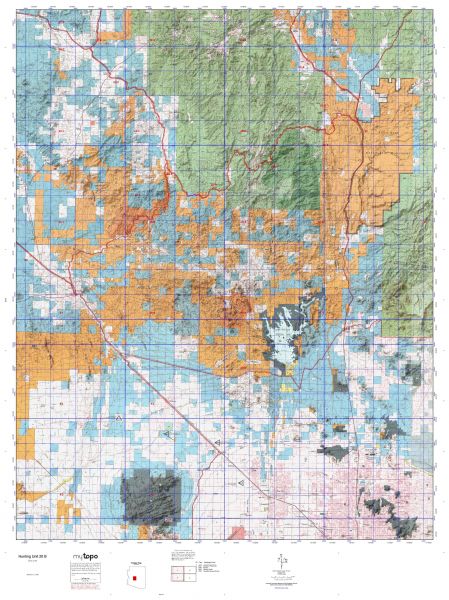
The actual boundary description/definitions printed below from the Oregon Division of Wildlife hunting regulations brochure could have errors or been amended by the state so always check in their most current printed regulations or the Oregon Division of Wildlife website to verify these boundaries before hunting as these are for reference only.

Oregon Big Game

– (Moffat) bounded on N, East, and South by Green River; on West by Utah.

Click Here to Order Unit 35 Topo Map

Unit description

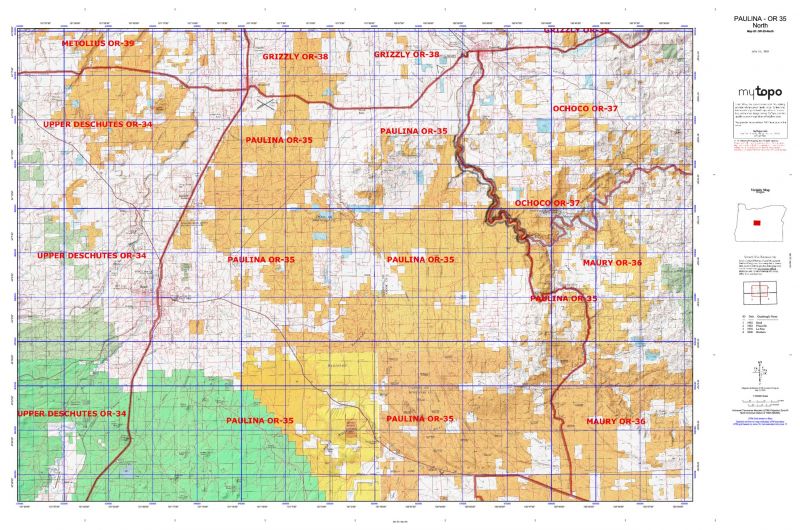
PAULINA 76% of public lands. Beginning at Redmond; east on State Highway 126 to Prineville; southeast on State Highway 27 to United States Highway 20; northwest on Highway 20 to Millican-Lk Road 2-1/2 mile east of Millican; southeast and south on Millican-Lk Road past Dickerson Well and Janes Well (Lk Company Road 5-12D) to the intersection of Lk Company Road 5-12B; east on Lk Company Road 5-12B to the intersection of Lk Company Road 5-14C; south on Lk Company Road 5-14C to the junction of Lk Company Road 5-14; 2 miles east of Christmas Valley; west on Lk Company Road 5-14 13 miles to junction with Lk Company Road 5-10; 22 miles north and west on Lk Company Road 5-10 to State Highway 31; northwest on Highway 31 to Gilchrist main logging Road 9775 between MP 16 and 17; west on Gilchrist main logging Road to United States Highway 97; northeast on Highway 97 to Redmond, point of beginning. (Maps: Deschutes National Forest, Prineville/Lakeview Bureau of Land Management)


Shopping cart
Sign in

No account yet?

Start typing to see products you are looking for.
Shop
0 Wishlist
0 items Cart
My account