
Oregon Unit 16 Topo Maps Hunting & Unit Maps
Sold out

Oregon Unit 16 Topo Maps Hunting & Unit Maps
Currently there are 20 peoples are currently looking at this product
Spend $1,000.00 for FREE SHIPPING
Description
Customer Review
Be the first to review “Oregon Unit 16 Topo Maps Hunting & Unit Maps ” Cancel reply
Click Here to View Large Map or Order
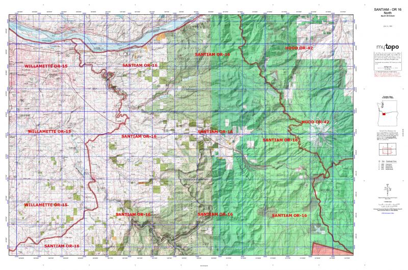
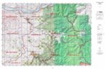
Oregon Unit 16 hunting map topo with printed boundaries
HuntersDomain has Oregon unit 16 hunt area maps that are 1:100,000-scale maps using Bureau of Land Management land status base maps.
Our UNIT 16 maps include:
- Oregon public land ownership boundaries
- Topographical contour lines
- 1:100,000 scale for easy viewing
- Roads printed
- Key terrain features to help you plan your hunt or trip
- Hunt area or game management unit 16 (GMU 16) boundary is overlaid on the BLM base map
- Easy planning for your upcoming big game hunt by defining roads and routes into the preferred area
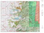
Custom maps for unit 16 are also available (See it all on one map):
- Color aerial photo maps: high resolution (you define borders/boundaries)
- TOPO maps only where you easily define borders or edges of maps with our online program
- Hybrid maps: a unique and detailed aerial photo combined with a USGS topographical maps (user-defined boundaries)
Order your unit 16 Oregon topo map today!
The actual boundary description/definitions printed below from the Oregon Division of Wildlife hunting regulations brochure could have errors or been amended by the state so always check in their most current printed regulations or the Oregon Division of Wildlife website to verify these boundaries before hunting as these are for reference only.
– (Moffat) bounded on N, East, and South by Green River; on West by Utah.
Click Here to Order Unit 16 Topo Map
Unit description
Santiam 63% of public lands. Beginning at Lebanon; north on Brewster Road to Lacomb Road; east on Lacomb Road to Kowitz Road; north on Kowitz Road to Baptist Church Dr; west on Baptist Church Dr to Richardson Gap Road; north on Richardson Gap Road to State Highway 226; northeast on Highway 226 to State Highway 22; west on Highway 22 to Cascade Highway; north on Cascade Highway to State Highway 213 at Silverton; northeast on Highway 213 to State Highway 211; northeast on Highway 211 to Sandy; north on Teneyck Road to Sandy River; northwest down Sandy River to state line in Columbia River; northeast on state line to Multnomah-Hood River Company line; southeast on Multnomah-Hood River Company line to Lolo Pass; southeast on Pacific Crest Trail to Barlow Pass; west on Highway 35 to Highway 26; southeast on Highway 26 to Highway 216; west and then south along the west boundary of The Confederated Tribes of Warm Springs Tribal Reservation (CTWSRO) (McQuinn Strip line) to summilet of Mount Jefferson; south along the west CTWSRO boundary and the Cascade crest (Jefferson/Linn Company line) to the junction of the Pacific Crest National Scenic Trail (PCT) in T11S, R8E Sec 17 then south on PCT to United States Highway 20/126 at Santiam Pass; PCT west on United States Highway 20 to Lebanon, point of beginning. (The McQuinn Strip portion of White River Unit and Warm Springs Tribal Reservation was closed to public hunting Sept. 21, 1992, until further notice). (Maps: Mount Hood National Forest, Willamette National Forest, Salem Bureau of Land Management)


Reviews
There are no reviews yet.