
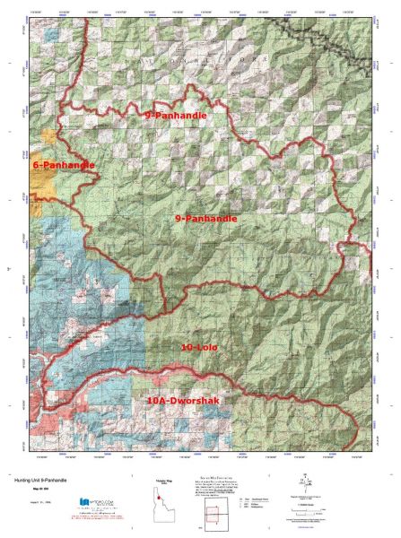
Idaho Hunting Unit 9 Panhandle Topo Maps
Sold out
Idaho Hunting Unit 9 Panhandle Topo Maps
Categories: Hunting Topo Maps by Unit, Idaho GMU 9 Hunting Topo Maps, Idaho Topo Maps
Tag: Idaho GMU 9 Hunting
Currently there are 20 peoples are currently looking at this product
Spend $1,000.00 for FREE SHIPPING
Description
Customer Review
Be the first to review “Idaho Hunting Unit 9 Panhandle Topo Maps” Cancel reply
Click Here to View Large Map or Order
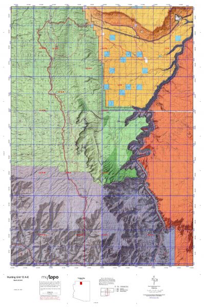
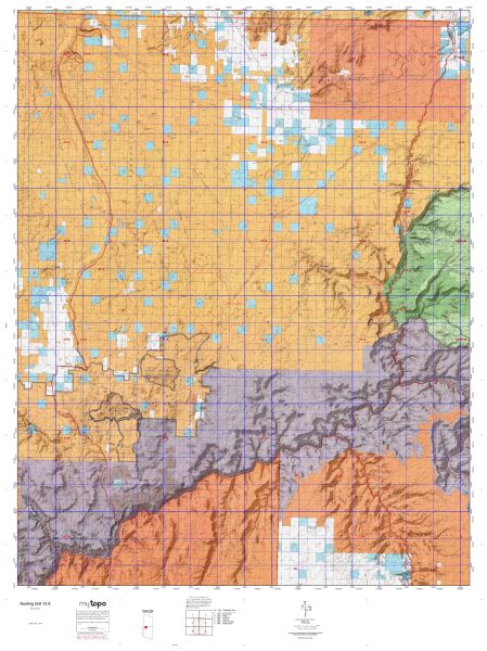
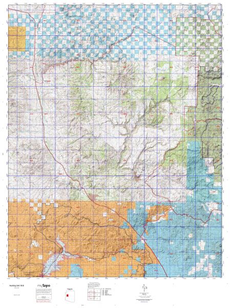
Idaho Unit 9 hunting map topo with printed boundaries
HuntersDomain has Idaho unit 9 hunt area maps that are 1:100,000-scale maps using Bureau of Land Management land status base maps.
Our UNIT 9 maps include:
- Idaho public land ownership boundaries
- Topographical contour lines
- 1:100,000 scale for easy viewing
- Roads printed
- Key terrain features to help you plan your hunt or trip
- Hunt area or game management unit 9 (GMU 9) boundary is overlaid on the BLM base map
- Easy planning for your upcoming big game hunt by defining roads and routes into the preferred area
Custom maps for unit 9 are also available (See it all on one map):
- Color aerial photo maps: high resolution (you define borders/boundaries)
- TOPO maps only where you easily define borders or edges of maps with our online program
- Hybrid maps: a unique and detailed aerial photo combined with a USGS topographical maps (user-defined boundaries)
Order your unit 9 Idaho topo map today!
The actual boundary description/definitions printed below from Idaho Division of Wildlife hunting regulations brochure could have errors or been amended by the state so always check in their most current printed regulations or the Idaho Division of Wildlife website to verify these boundaries before hunting as these are for reference only.
– Unit 9 Topo/Map Idaho – Game Management Unit (GMU-9).
Game Management Unit (GMU)
BLM Maps:
Reservation Land
US Forest Service Maps:
Reservation land
Click Here to Order Unit 9 Topo Map
Unit description
Unit 9 Panhandle: Those portions of Shoshone and Clearwater counties within the following boundary: beginning at Getaway Point, then due south to the Little North Fork of the Clearwater River, then upstream to the watershed divide between Bear and Devils Club Creeks, then east along the divide to Larkins Peak, then northeast along the watershed divide between the Little North Fork of the Clearwater River and the North Fork of the Clearwater River to the Surveyors Ridge-Bathtub Springs Road (Forest Service Road 201), then northwest on Surveyors Ridge-Bathtub Springs Road past Bathtub Springs and Bluff Creek Saddle (Dismal Saddle), to the Fishhook Creek Road (Forest Service Road 301), then south on Fishhook Creek Road to Breezy Saddle, then southwest on Fishhook Creek Road to the Goat Mountain-Getaway Point Road, then southeast on the Goat Mountain-Getaway Point Road to Getaway Point, the point of beginning.


Reviews
There are no reviews yet.