
Idaho Hunting Unit 16A Selway Topo Maps
Sold out
Idaho Hunting Unit 16A Selway Topo Maps
Currently there are 20 peoples are currently looking at this product
Spend $1,000.00 for FREE SHIPPING
Description
Customer Review
Be the first to review “Idaho Hunting Unit 16A Selway Topo Maps” Cancel reply
Click Here to View Large Map or Order
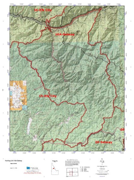
Idaho Unit 16A hunting map topo with printed boundaries
HuntersDomain has Idaho unit 16A hunt area maps that are 1:100,000-scale maps using Bureau of Land Management land status base maps.
Our UNIT 16A maps include:
- Idaho public land ownership boundaries
- Topographical contour lines
- 1:100,000 scale for easy viewing
- Roads printed
- Key terrain features to help you plan your hunt or trip
- Hunt area or game management unit 16A (GMU 16A) boundary is overlaid on the BLM base map
- Easy planning for your upcoming big game hunt by defining roads and routes into the preferred area
Custom maps for unit 16A are also available (See it all on one map):
- Color aerial photo maps: high resolution (you define borders/boundaries)
- TOPO maps only where you easily define borders or edges of maps with our online program
- Hybrid maps: a unique and detailed aerial photo combined with a USGS topographical maps (user-defined boundaries)
Order your unit 16A Idaho topo map today!
The actual boundary description/definitions printed below from Idaho Division of Wildlife hunting regulations brochure could have errors or been amended by the state so always check in their most current printed regulations or the Idaho Division of Wildlife website to verify these boundaries before hunting as these are for reference only.
– Unit 16A Topo/Map Idaho – Game Management Unit (GMU-16A).
Game Management Unit (GMU)
BLM Maps:
Reservation Land
US Forest Service Maps:
Reservation land
Click Here to Order Unit 16A Topo Map
Unit description
Unit 16A Selway: That portion of Idaho County within the following boundary: beginning at the mouth of Meadow Creek on the Selway River, up the Selway River to Mink Creek, then up the divide between Mink Creek and the drainages of Coyote, Wolf, Jims, and Otter Creeks, over Wolf Point and Highline Ridge to the divide between Meadow Creek and the Selway River, then southeast along the divide over Bilk Mountain and Elk Mountain to the Elk Mountain Road, then southwest on the Elk Mountain-Green Mountain- Montana Road to the watershed divide between the South Fork of the Clearwater River and the Selway River (near Mountain Meadows), then northeast along the divide over Soda Creek Point and around the head of Red River, then northwest along the divide over Black Hawk Mountain to Anderson Butte, then from Anderson Butte northwest on Forest Service Trail 835 to the Falls Point Road (Forest Service Road 443), then northeast on Falls Point Road to the mouth of Meadow Creek, the point of beginning.


Reviews
There are no reviews yet.