Idaho GMU 11A Hunting

Idaho GMU 11A Hunting

Currently there are 20 peoples are currently looking at this product

Spend $1,000.00 for FREE SHIPPING

Description
Customer Review

Reviews

There are no reviews yet.

Be the first to review “Idaho GMU 11A Hunting”

Your email address will not be published. Required fields are marked *

Click Here to View Large Map or Order


Idaho Unit 12 hunting map topo with printed boundaries

HuntersDomain has Idaho unit 12 hunt area maps that are 1:100,000-scale maps using Bureau of Land Management land status base maps.

Our UNIT 12 maps include:

  1. Idaho public land ownership boundaries
  2. Topographical contour lines
  3. 1:100,000 scale for easy viewing
  4. Roads printed
  5. Key terrain features to help you plan your hunt or trip
  6. Hunt area or game management unit 12 (GMU 12) boundary is overlaid on the BLM base map
  7. Easy planning for your upcoming big game hunt by defining roads and routes into the preferred area

Custom maps for unit 12 are also available (See it all on one map):

  1. Color aerial photo maps: high resolution (you define borders/boundaries)
  2. TOPO maps only where you easily define borders or edges of maps with our online program
  3. Hybrid maps: a unique and detailed aerial photo combined with a USGS topographical maps (user-defined boundaries)

Order your unit 12 Idaho topo map today!

The actual boundary description/definitions printed below from Idaho Division of Wildlife hunting regulations brochure could have errors or been amended by the state so always check in their most current printed regulations or the Idaho Division of Wildlife website to verify these boundaries before hunting as these are for reference only.

Idaho Big Game Unit 12

– Unit 12 Topo/Map Idaho – Game Management Unit (GMU-12).

Game Management Unit (GMU)

BLM Maps:

Reservation Land

US Forest Service Maps:

Reservation land

Click Here to Order Unit 12 Topo Map

Unit description

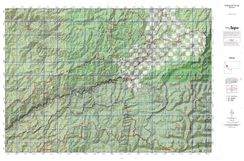
Unit 12 Lolo: Those portions of Idaho and Clearwater counties within the following boundary: beginning at the junction of the Smith Creek Road (Forest Service Road 101) and the Middle Fork of the Clearwater River, then northeast on the Smith Creek Road to the Lolo Motor Way (Forest Service Road 500), then north along the Lolo Motor Way to the point where it leaves the watershed divide between the North Fork of the Clearwater and Lochsa Rivers at the heads of Papoose Creek and Cayuse Creek, then north along the divide over Williams Peak to the Idaho-Montana State line, then southeast along the state line to the watershed divide between the Lochsa and Selway Rivers, then west along the divide over Diablo Mountain, Elk Summit, McConnell Mountain and Fenn Mountain to the confluence of the Lochsa and Selway Rivers, then down the Middle Fork of the Clearwater River to the Smith Creek Road, the point of beginning.


Shopping cart
Sign in

No account yet?

Start typing to see products you are looking for.
Shop
0 Wishlist
0 items Cart
My account