Click Here to View Large Map or to Purchase
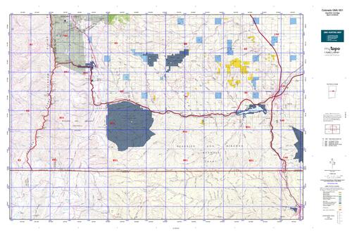
Colorado Unit 851 Hunting Topo Map with Printed Boundaries
Hunters Domain has Colorado Unit 851 hunt area maps that are 1:100,000-scale maps using Bureau of Land Management land status base maps.
Our UNIT 851 maps include:
Colorado public land ownership boundaries
Topographical contour lines
1:100,000 scale for easy viewing
Roads printed
Key terrain features to help you plan your hunt or trip
Hunt area or game management unit 851 (GMU 851) boundary is overlaid on the BLM base map
Easy planning for your upcoming big game hunt by defining roads and routes into the preferred area
Custom maps for Unit 851 are also available (See it all on one map):
Color aerial photo maps: high resolution (you define borders/boundaries)
TOPO maps only where you easily define borders or edges of maps with our online program
Hybrid maps: a unique and detailed aerial photo combined with a USGS topographical maps (user-defined boundaries)
Order your Colorado Unit 851 Map Today!
The actual boundary description/definitions printed below from Colorado Parks and Wildlife hunting regulations brochure could have errors or been amended by the state so always check in their most current printed regulations or the Colorado Parks and Wildlife website to verify these boundaries before hunting as these are for reference only.
Colorado Big Game Unit 851
– Unit 851 Topo/Map Colorado – Game Management Unit (GMU-851).
Game Management Unit (GMU)
BLM Maps:
Reservation Land
US Forest Service Maps:
Reservation land
Click Here to Order Your Color Colorado Unit 851 Hunting Map
Colorado Unit 851 Description
Unit 851 Located in Costilla and Las Animas Counties bounded on the North by West and North forks of Purgatoire River and Colorado 12; on the East by I-25; on the South by New Mexico border; on the West by Sangre de Cristo divide.
GMU 851 Elevation: 14,053 feet on Culebra Peak to 6,025 feet near Trinidad. Terrain: Moderately steep and steep foothills to steep mountains. Vegetation: Grass to pine to spruce, firs and aspens to alpine meadows. Weather: Variable, but first freeze of snow could occur in mid-Sept. at higher elevations. Land Status: 98 percent private with some state land available. Hunter Access: There is very little public land in 851. There is a small portion of USFS
land available on north boundary. The only other major public portion of 851 for big game hunting is the Bosque del Oso SWA, which is draw only for turkey and big game.


Reviews
There are no reviews yet.