Click Here to View Large Map or Order
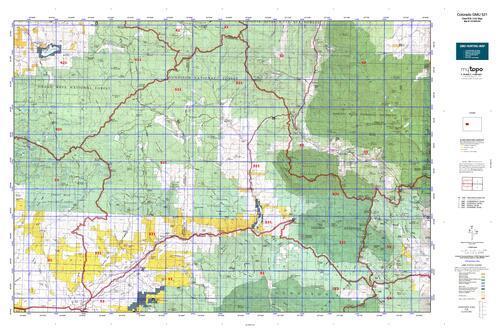
Colorado Unit 521 Hunting Topo Map with Printed Boundaries
Hunters Domain has Colorado Unit 521 hunt area maps that are 1:100,000-scale maps using Bureau of Land Management land status base maps.
Our UNIT 521 maps include:
Colorado public land ownership boundaries
Topographical contour lines
1:100,000 scale for easy viewing
Roads printed
Key terrain features to help you plan your hunt or trip
Hunt area or game management unit 521 (GMU 521) boundary is overlaid on the BLM base map
Easy planning for your upcoming big game hunt by defining roads and routes into the preferred area
Custom maps for Unit 521 are also available (See it all on one map):
Color aerial photo maps: high resolution (you define borders/boundaries)
TOPO maps only where you easily define borders or edges of maps with our online program
Hybrid maps: a unique and detailed aerial photo combined with a USGS topographical maps (user-defined boundaries)
Order your Colorado Unit 521 Map Today!
The actual boundary description/definitions printed below from Colorado Parks and Wildlife hunting regulations brochure could have errors or been amended by the state so always check in their most current printed regulations or the Colorado Parks and Wildlife website to verify these boundaries before hunting as these are for reference only.
Colorado Big Game Unit 521
– Unit 521 Topo/Map Colorado – Game Management Unit (GMU-521).
Game Management Unit (GMU)
BLM Maps:
Reservation Land
US Forest Service Maps:
Reservation land
Click Here to Order Your Colorado Unit 521 Topo Map
Colorado Unit 521 Description
Unit 521 South Grand Mesa Region: Gunnison and Delta Counties bounded on the North by the Delta and Mesa County lines and the Gunnison-Mesa County line; on the East by Gunnison-Pitkin County line, White River-Gunnison NF boundary and Ruby Range Summit; on the South by Gunnison CR
12 (Kebler Pass Rd.) and North Fork of Gunnison River; on the West by Jay Creek, West Res. No. 1, Overland Ditch and Grand Mesa-Gunnison NF boundary.
The Grand Mesa region is heavily forested and offers a wide variety of terrains. You will find spruce, fir
and aspen forests up to 11,000 feet, to the pinon-juniper woodlands at about 4,800 feet. Weather can vary as widely as the terrain. Motorized access is good but roads can become muddy. Hunters should obtain maps to avoid trespassing or unintentionally crossing private land.


Reviews
There are no reviews yet.