Click Here to View Large Map or to Purchase
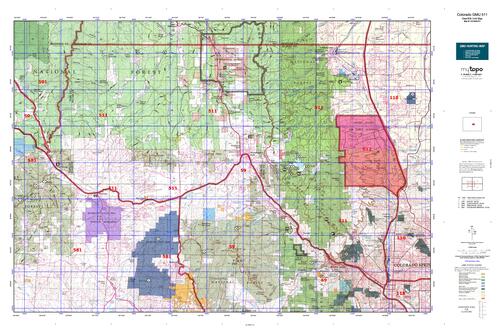
Colorado Unit 511 Hunting Topo Map with Printed Boundaries
Hunters Domain has Colorado Unit 511 hunt area maps that are 1:100,000-scale maps using Bureau of Land Management land status base maps.
Our UNIT 511 maps include:
Colorado public land ownership boundaries
Topographical contour lines
1:100,000 scale for easy viewing
Roads printed
Key terrain features to help you plan your hunt or trip
Hunt area or game management unit 511 (GMU 511) boundary is overlaid on the BLM base map
Easy planning for your upcoming big game hunt by defining roads and routes into the preferred area
Custom maps for Unit 511 are also available (See it all on one map):
Color aerial photo maps: high resolution (you define borders/boundaries)
TOPO maps only where you easily define borders or edges of maps with our online program
Hybrid maps: a unique and detailed aerial photo combined with a USGS topographical maps (user-defined boundaries)
Order your Colorado Unit 511 Map Today!
The actual boundary description/definitions printed below from Colorado Parks and Wildlife hunting regulations brochure could have errors or been amended by the state so always check in their most current printed regulations or the Colorado Parks and Wildlife website to verify these boundaries before hunting as these are for reference only.
Colorado Big Game Unit 511
– Unit 511 Topo/Map Colorado – Game Management Unit (GMU-511).
Game Management Unit (GMU)
BLM Maps:
Reservation Land
US Forest Service Maps:
Reservation land
Click Here to Order Your Color Colorado Unit 511 Hunting Map
Colorado Unit 511 Description
Unit 511 Located in Park, Teller and El Paso Counties bounded on the North by Douglas County line; on the East by I-25; on the South by U.S. 24; on the West by South Platte River, except on U.S. Air Force Academy.
GMU 511 Elevation: 9,423 feet on Blodgett Peak to 6,400 in Colorado Springs. Terrain: Consists of mostly steep to moderately steep mountains with rocky outcrops. Vegetation: Pine & oakbrush or pine & meadows at low elevations to spruce & fir higher. Weather: Variable. Look for first snow or freeze in early October. Land Status: Approximately 60 percent public. Private property parcels and restricted government land border Rampart Range road so hunters must mind land status. Be aware that Douglas County is a limited license area for elk. Note: The Air Force Academy is
stand-alone GMU 512. Hunter Access: Good. Public roads provide access to public lands. Access is from the north and northwest of Divide, either side of Hwy. 67 north of Woodland Park and on either side of the Rampart Range Road from about Ormes Peak to the Douglas-El Paso county line. Mule Deer: Look for deer at lower elevations in the oakbrush and pines or adjacent to meadows at higher elevations. Areas with forest thinning operations and wild land fires have provided good deer habitat. In later seasons look for deer along Camp Creek. Elk: Elk found just about anywhere in the unit. Look for elk in the Trout Creek drainage. During early seasons, look for elk near South Beaver Creek and Rampart Reservoir.


Reviews
There are no reviews yet.