Click Here to View Large Map or to Purchase
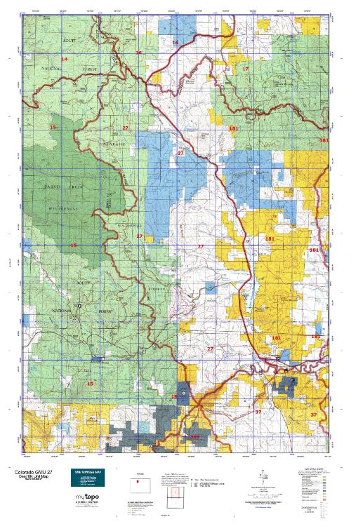
Colorado Unit 27 Hunting Topo Map with Printed Boundaries
Hunters Domain has Colorado Unit 27 hunt area maps that are 1:100,000-scale maps using Bureau of Land Management land status base maps.
Our UNIT 27 maps include:
Colorado public land ownership boundaries
Topographical contour lines
1:100,000 scale for easy viewing
Roads printed
Key terrain features to help you plan your hunt or trip
Hunt area or game management unit 27 (GMU 27) boundary is overlaid on the BLM base map
Easy planning for your upcoming big game hunt by defining roads and routes into the preferred area
Custom maps for Unit 27 are also available (See it all on one map):
Color aerial photo maps: high resolution (you define borders/boundaries)
TOPO maps only where you easily define borders or edges of maps with our online program
Hybrid maps: a unique and detailed aerial photo combined with a USGS topographical maps (user-defined boundaries)
Order your Colorado Unit 27 Map Today!
The actual boundary description/definitions printed below from Colorado Parks and Wildlife hunting regulations brochure could have errors or been amended by the state so always check in their most current printed regulations or the Colorado Parks and Wildlife website to verify these boundaries before hunting as these are for reference only.
Colorado Big Game Unit 27
– Unit 27 Topo/Map Colorado – Game Management Unit (GMU-27).
Game Management Unit (GMU)
BLM Maps:
Reservation Land
US Forest Service Maps:
Reservation land
Click Here to Order Your Color Colorado Unit 27 Topo Map
Colorado Unit 27 Description
Unit 27 Located in Grand Routt and Jackson Counties bounded on the North and East by U.S. 40; on the South by Colorado Hwy 9 and the Colorado River; on the West by Canyon Creek and Muddy Creek-Yampa River divide (Gore Range divide).
GMU 27 The Continental Divide and the Gore Range Divide encircle Middle Park. Most of this terrain is steep to very steep. The weather can change rapidly. Areas can become snowbound. 4WD is recommended, along with chains.
Sagebrush/shrubs are common on southern exposures at lower elevations. The valley bottoms are mostly private lands. The remaining 2/3 of this area is public land. The buck-to-doe ratios continue to increase as a result of limited buck hunting and mild winters. All units are managed for quality bucks. There are good numbers of mature bucks, but they rarely reach trophy status found in lower elevation mtn shrub & mild winter areas. Concentrate on transition zones that have aspen, shrub and coniferous cover. Deer tend to move west and down in elevation over the seasons, snow will move them faster and farther. Bull to cow ratios are good because the area is fairly steep and heavily timbered. Generally, trophy bulls are rare (a few are taken every year) because bulls are managed for hunter opportunity. With hunting pressure and snow, elk head for the inaccessible timber and private property. GMU 27 has a lot of private land. Hunt the rough terrain and heavy cover away from roads and trails to increase your success.


Reviews
There are no reviews yet.