Click Here to View Large Map or to Purchase
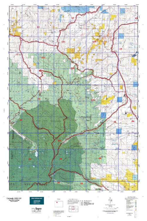
Colorado Unit 231 Hunting Topo Map with Printed Boundaries
Hunters Domain has Colorado Unit 231 hunt area maps that are 1:100,000-scale maps using Bureau of Land Management land status base maps.
Our UNIT 231 maps include:
Colorado public land ownership boundaries
Topographical contour lines
1:100,000 scale for easy viewing
Roads printed
Key terrain features to help you plan your hunt or trip
Hunt area or game management unit 231 (GMU 231) boundary is overlaid on the BLM base map
Easy planning for your upcoming big game hunt by defining roads and routes into the preferred area
Custom maps for Unit 231 are also available (See it all on one map):
Color aerial photo maps: high resolution (you define borders/boundaries)
TOPO maps only where you easily define borders or edges of maps with our online program
Hybrid maps: a unique and detailed aerial photo combined with a USGS topographical maps (user-defined boundaries)
Order your Colorado Unit 231 Map Today!
The actual boundary description/definitions printed below from Colorado Parks and Wildlife hunting regulations brochure could have errors or been amended by the state so always check in their most current printed regulations or the Colorado Parks and Wildlife website to verify these boundaries before hunting as these are for reference only.
Colorado Big Game Unit 231
– Unit 231 Topo/Map Colorado – Game Management Unit (GMU-231).
Game Management Unit (GMU)
BLM Maps:
Reservation Land
US Forest Service Maps:
Reservation land
Click Here to Order Your Color Colorado Unit 231 Topo Map
Colorado Unit 231 Description
Unit 231 Located in Routt, Rio Blanco and Garfield Counties bounded on the North by Routt CRs 29, 132A, 25, 132 & 15; on the East by Colorado 131; on the South by Bear River; on the West by Williams Fork-Yampa River divide to Dunkley Pass, Rio Blanco CRs 8 & 19 and Routt CR 55.
GMU 231 Expect light to moderate snow in the 1st season, gradually increasing through the 4th season. 4WD is usually necessary on the secondary roads. Elk are plentiful throughout the Upper Yampa area. The basic movement is from the higher to lower elevation in response to hunting pressure and weather.


Reviews
There are no reviews yet.