Click Here to View Large Map or to Purchase
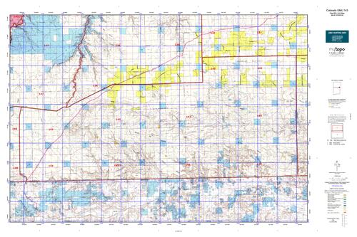
Colorado Unit 143 Hunting Topo Map with Printed Boundaries
Hunters Domain has Colorado Unit 143 hunt area maps that are 1:100,000-scale maps using Bureau of Land Management land status base maps.
Our UNIT 143 maps include:
Colorado public land ownership boundaries
Topographical contour lines
1:100,000 scale for easy viewing
Roads printed
Key terrain features to help you plan your hunt or trip
Hunt area or game management unit 143 (GMU 143) boundary is overlaid on the BLM base map
Easy planning for your upcoming big game hunt by defining roads and routes into the preferred area
Custom maps for Unit 143 are also available (See it all on one map):
Color aerial photo maps: high resolution (you define borders/boundaries)
TOPO maps only where you easily define borders or edges of maps with our online program
Hybrid maps: a unique and detailed aerial photo combined with a USGS topographical maps (user-defined boundaries)
Order your Colorado Unit 143 Map Today!
The actual boundary description/definitions printed below from Colorado Parks and Wildlife hunting regulations brochure could have errors or been amended by the state so always check in their most current printed regulations or the Colorado Parks and Wildlife website to verify these boundaries before hunting as these are for reference only.
Colorado Big Game Unit 143
– Unit 143 Topo/Map Colorado – Game Management Unit (GMU-143).
Game Management Unit (GMU)
BLM Maps:
Reservation Land
US Forest Service Maps:
Reservation land
Click Here to Order Your Color Colorado Unit 143 Hunting Map
Colorado Unit 143 Description
Unit 143 Located in Las Animas County bounded on the North by U.S. 160; on the East by Baca-Las Animas County line; on the South by OK & NM; on the West by Colorado 389.
GMU 143 Elevation: 4,250 to 6,821 feet. Terrain: Gently rolling, changing quickly to steep mesas and canyons.
Vegetation: Shortgrass prairie to pinons, junipers to pines and oak. Weather: First freeze or snow possible mid-October. Possible severe blizzards by December. Land status: 95 percent private, remainder Comanche National Grasslands. Hunter Access: Poor for deer and pronghorn, most private land leased to outfitters. Access may be better SW of Pritchett. Deer: Expect to pay substantial fee to hunt deer on private land in this unit. Pronghorn: May be found on Comanche National Grasslands near and around Kim. Small Game: Hunting is fair for cottontails. Small numbers of scaled quail may be found where appropriate habitat exists (yucca, cactus, and sage). Low densities of turkeys exist in the mesa and canyon areas.


Reviews
There are no reviews yet.