Click Here to View Large Map or to Purchase
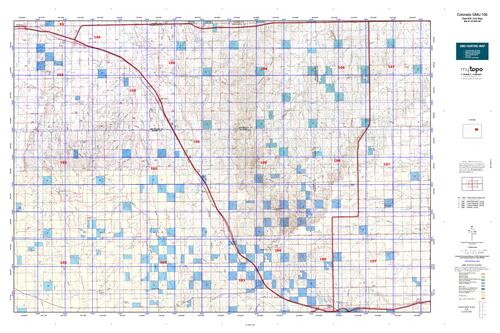
Colorado Unit 106 Hunting Topo Map with Printed Boundaries
Hunters Domain has Colorado Unit 106 hunt area maps that are 1:100,000-scale maps using Bureau of Land Management land status base maps.
Our UNIT 106 maps include:
Colorado public land ownership boundaries
Topographical contour lines
1:100,000 scale for easy viewing
Roads printed
Key terrain features to help you plan your hunt or trip
Hunt area or game management unit 106 (GMU 106) boundary is overlaid on the BLM base map
Easy planning for your upcoming big game hunt by defining roads and routes into the preferred area
Custom maps for Unit 106 are also available (See it all on one map):
Color aerial photo maps: high resolution (you define borders/boundaries)
TOPO maps only where you easily define borders or edges of maps with our online program
Hybrid maps: a unique and detailed aerial photo combined with a USGS topographical maps (user-defined boundaries)
Order your Colorado Unit 106 Map Today!
The actual boundary description/definitions printed below from Colorado Parks and Wildlife hunting regulations brochure could have errors or been amended by the state so always check in their most current printed regulations or the Colorado Parks and Wildlife website to verify these boundaries before hunting as these are for reference only.
Colorado Big Game Unit 106
– Unit 106 Topo/Map Colorado – Game Management Unit (GMU-106).
Game Management Unit (GMU)
BLM Maps:
Reservation Land
US Forest Service Maps:
Reservation land
Click Here to Order Your Color Colorado Unit 106 Hunting Map
Colorado Unit 106 Description
Unit 106 Located in Washington, Lincoln, Arapaho and Elbert Counties bounded on the North by U.S. 36; on the East by Colorado 71; on the South and West by I-70.
GMU 106 Elevation: 6,500 to 4,922 feet. Terrain: Flat to gently rolling prairies. Some moderately steep areas including steep “break” country interspersed with canyons. Vegetation: Primarily shortgrass prairie with interspersed wheat crops. Cedar, ponderosa pine and cottonwood tree stands may be found in northeast portion of unit. Weather: Mild and dry. First freeze or snow may occur in mid-October to mid November. There is the possibility of severe winter weather by December. Land Status: 100 percent private. Hunter Access: By permission only.


Reviews
There are no reviews yet.