Click Here to View Large Map or to Purchase
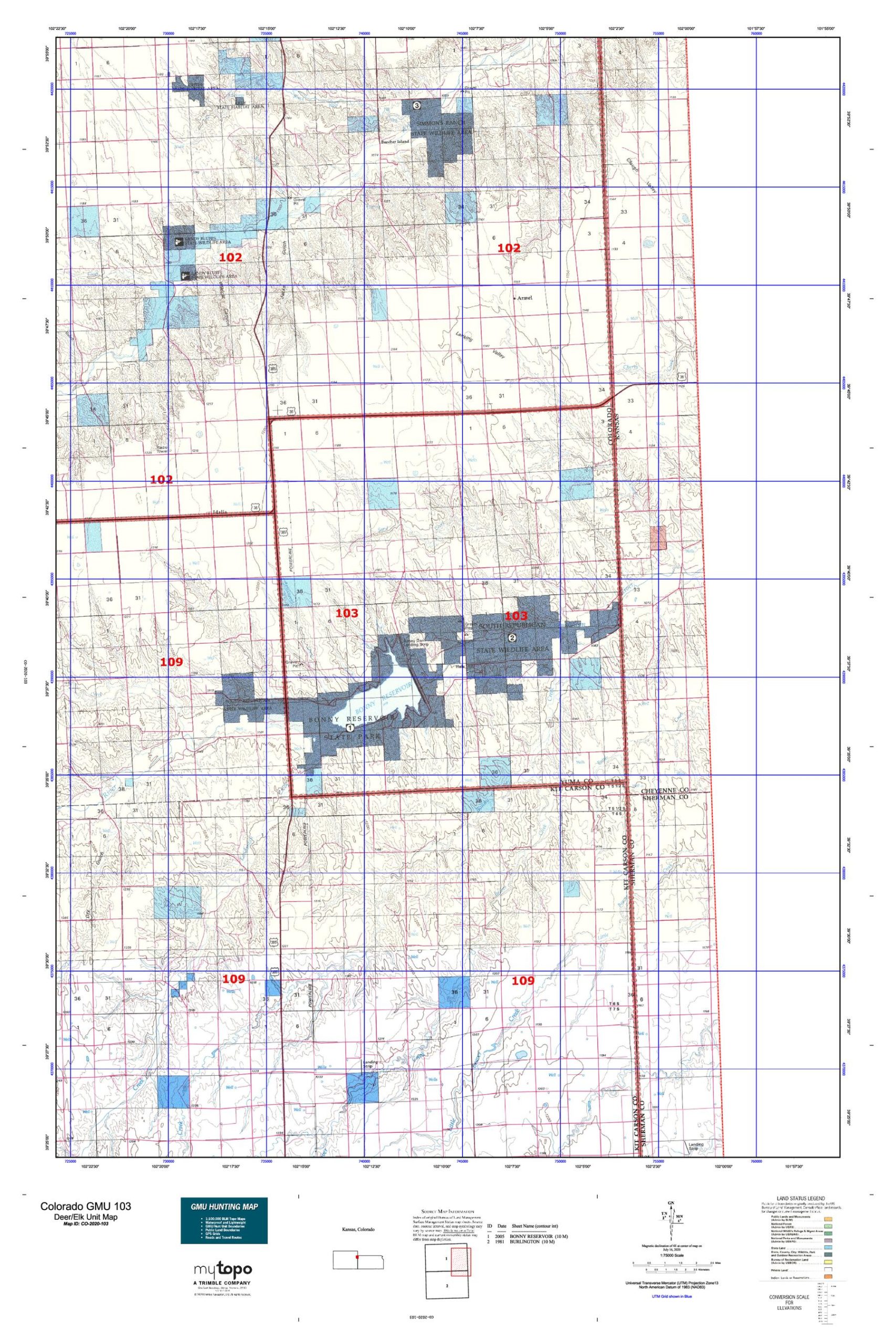
Colorado Unit 103 Hunting Topo Map with Printed Boundaries
Hunters Domain has Colorado Unit 103 hunt area maps that are 1:100,000-scale maps using Bureau of Land Management land status base maps.
Our UNIT 103 maps include:
Colorado public land ownership boundaries
Topographical contour lines
1:100,000 scale for easy viewing
Roads printed
Key terrain features to help you plan your hunt or trip
Hunt area or game management unit 103 (GMU 103) boundary is overlaid on the BLM base map
Easy planning for your upcoming big game hunt by defining roads and routes into the preferred area
Custom maps for Unit 103 are also available (See it all on one map):
Color aerial photo maps: high resolution (you define borders/boundaries)
TOPO maps only where you easily define borders or edges of maps with our online program
Hybrid maps: a unique and detailed aerial photo combined with a USGS topographical maps (user-defined boundaries)
Order your Colorado Unit 103 Map Today!
The actual boundary description/definitions printed below from Colorado Parks and Wildlife hunting regulations brochure could have errors or been amended by the state so always check in their most current printed regulations or the Colorado Parks and Wildlife website to verify these boundaries before hunting as these are for reference only.
Colorado Big Game Unit 103
– Unit 103 Topo/Map Colorado – Game Management Unit (GMU-103).
Game Management Unit (GMU)
BLM Maps:
Reservation Land
US Forest Service Maps:
Reservation land
Click Here to Order Your Color Colorado Unit 103 Hunting Map
Colorado Unit 103 Description
Unit 103 Located in Yuma County bounded on the North by U.S. 36; on the East by Kansas border; on the South by Kit Carson-Yuma County line; on the West by U.S. 385.
GMU 103 Elevation: 3,550 to 3,835 feet. Terrain: Consists of flat to gently rolling. Vegetation: Short grass prairies, farms, cottonwoods, willows. Weather: Mild and dry. First freeze or snow may occur in mid- October to mid-November. Land Status: Approximately 65 percent private land. Hunter Access: Good for public land; fair for private land. Deer: Found in the riparian bottoms and cornfields during early seasons. Riparian bottoms and adjacent sagebrush draws, up to two or three miles out of bottoms during late seasons. Small game: Good pheasant hunting in farming areas; cottontails are abundant.


Reviews
There are no reviews yet.