Click Here to View Large Map or to Purchase
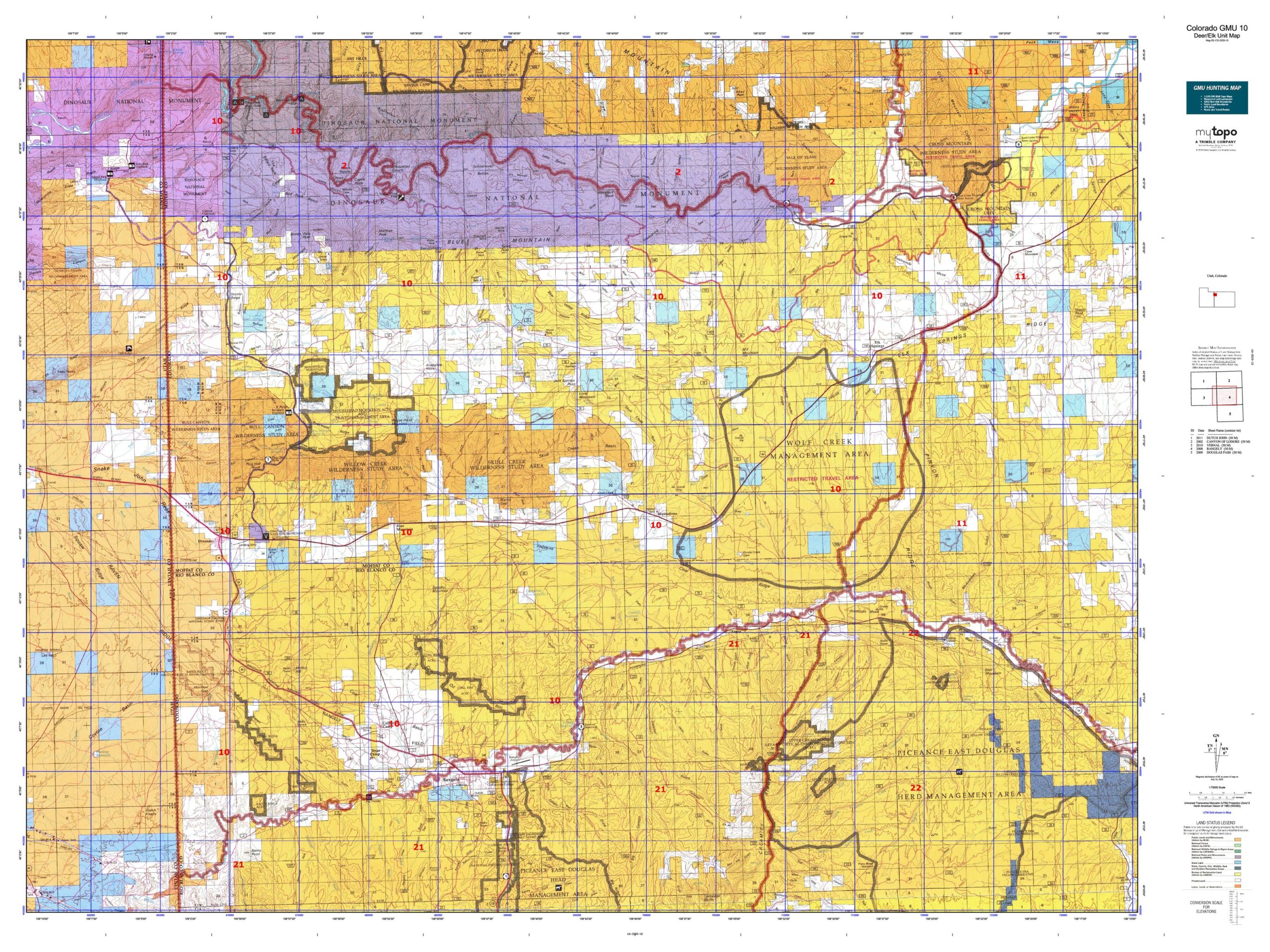
Colorado Unit 10 Hunting Topo Map with Printed Boundaries
Hunters Domain has Colorado Unit 10 hunt area maps that are 1:100,000-scale maps using Bureau of Land Management land status base maps.
Our UNIT 10 maps include:
Colorado public land ownership boundaries
Topographical contour lines
1:100,000 scale for easy viewing
Roads printed
Key terrain features to help you plan your hunt or trip
Hunt area or game management unit 10 (GMU 10) boundary is overlaid on the BLM base map
Easy planning for your upcoming big game hunt by defining roads and routes into the preferred area
Custom maps for Unit 10 are also available (See it all on one map):
Color aerial photo maps: high resolution (you define borders/boundaries)
TOPO maps only where you easily define borders or edges of maps with our online program
Hybrid maps: a unique and detailed aerial photo combined with a USGS topographical maps (user-defined boundaries)
Order your Colorado Unit 10 Map Today!
The actual boundary description/definitions printed below from Colorado Parks and Wildlife hunting regulations brochure could have errors or been amended by the state so always check in their most current printed regulations or the Colorado Parks and Wildlife website to verify these boundaries before hunting as these are for reference only.
Colorado Big Game Unit 10
– Unit 10 Topo/Map Colorado – Game Management Unit (GMU-10).
Game Management Unit (GMU)
BLM Maps:
Reservation Land
US Forest Service Maps:
Reservation land
Click Here to Order Your Color Colorado Unit 10 Topo Map
Colorado Unit 10 Description
Unit 10 Located in Moffat and Rio Blanco Counties bounded on the North by Green and Yampa rivers; on the East by Twelvemile Gulch Rd., U.S. 40 to mile marker 38.3 to Elk Springs Ridge to Drill Hole, Winter Valley Gulch, Coal Creek and Wolf Creek; on the South by the White River; on the West by the Utah border.
GMU 10 Weather is generally mild through the later seasons, though the higher elevations can have significant snow accumulations. GMU 10 is mostly BLM land with a lot of scattered private land. Consult a map and be aware of where you are. Deer are scattered throughout Unit 1o. If there is a winter range migration, it is usually during 3rd season. There are trophy bucks in GMU 10, however they tend to have tall versus wide antlers. Hunters should focus on the brush-covered areas, high elevations early in the season, lower elevations later. Big 300 size bulls are common. The elk tend to stay put over the seasons. Movement is weather dependent. Overall, elk are scattered in GMU 10. We recommend Blue Mountain and Moosehead Mtn in GMU 10, but be prepared for rough terrain.


Reviews
There are no reviews yet.