Arizona Unit 6 B Topo Maps Hunting & Unit Maps

Arizona Unit 6 B Topo Maps Hunting & Unit Maps

Currently there are 20 peoples are currently looking at this product

Spend $1,000.00 for FREE SHIPPING

Description
Customer Review

Reviews

There are no reviews yet.

Be the first to review “Arizona Unit 6 B Topo Maps Hunting & Unit Maps”

Your email address will not be published. Required fields are marked *

Click Here to View Large Map or Order

Arizona Unit 6 B hunting map topo with printed boundaries

HuntersDomain has Arizona unit 6 B hunt area maps that are 1:100,000-scale maps using Bureau of Land Management land status base maps.

Our UNIT 6 B maps include:

  1. Arizona public land ownership boundaries
  2. Topographical contour lines
  3. 1:100,000 scale for easy viewing
  4. Roads printed
  5. Key terrain features to help you plan your hunt or trip
  6. Hunt area or game management unit 6 B (GMU 6 B) boundary is overlaid on the BLM base map
  7. Easy planning for your upcoming big game hunt by defining roads and routes into the preferred area

Custom maps for unit 6 B are also available (See it all on one map):

  1. Color aerial photo maps: high resolution (you define borders/boundaries)
  2. TOPO maps only where you easily define borders or edges of maps with our online program
  3. Hybrid maps: a unique and detailed aerial photo combined withe USGS topographical maps (user-defined boundaries)

Order your unit 6 B Arizona topo map today!

The actual boundary description/definitions printed below from the Arizona Division of Wildlife hunting regulations brochure could have errors or been amended by the state so always check in their most current printed regulations or the Arizona Division of Wildlife website to verify these boundaries before hunting as these are for reference only.

Arizona Big Game

Click Here to Order Unit 6 B Topo Map

Unit description

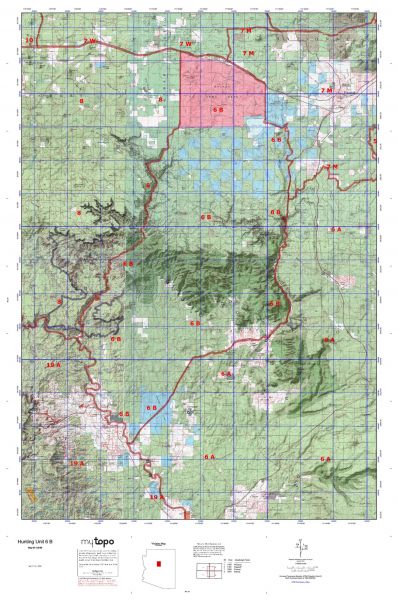
Unit 6 B Beginning at milepost 188.5 on Interstate-40 at a point just north of the east boundary of Camp Navajo; south along the eastern boundary of Camp Navajo to the southeastern corner of Camp Navajo; southeast approximately 1/3 mile through the forest to the forest road in section 33; southeast on the forest road to Forest Road 231 (Woody Mountain Road); easterly on Forest Road 231 to Forest Road 533; southerly on Forest Road 533 to United States Highway 89A; southerly on United States Highway 89A to the Verde River; northerly along the Verde River to Sycamore Creek; northeasterly along Sycamore Creek and Volunteer Canyon to the southwest corner of the Camp Navajo boundary; northerly along the western boundary of Camp Navajo to the northwest corner of Camp Navajo; continuing north to Interstate-40 (milepost 180.0); easterly along I-40 to milepost 188.5.


Shopping cart
Sign in

No account yet?

Start typing to see products you are looking for.
Shop
0 Wishlist
0 items Cart
My account