Arizona Unit 45 B Topo Maps Hunting & Unit Maps

Arizona Unit 45 B Topo Maps Hunting & Unit Maps

Currently there are 20 peoples are currently looking at this product

Spend $1,000.00 for FREE SHIPPING

Description
Customer Review

Reviews

There are no reviews yet.

Be the first to review “Arizona Unit 45 B Topo Maps Hunting & Unit Maps”

Your email address will not be published. Required fields are marked *

Click Here to View Large Map or Order

Arizona Unit 45 B hunting map topo with printed boundaries

HuntersDomain has Arizona unit 45 B hunt area maps that are 1:100,000-scale maps using Bureau of Land Management land status base maps.

Our UNIT 45 B maps include:

  1. Arizona public land ownership boundaries
  2. Topographical contour lines
  3. 1:100,000 scale for easy viewing
  4. Roads printed
  5. Key terrain features to help you plan your hunt or trip
  6. Hunt area or game management unit 45 B (GMU 45 B) boundary is overlaid on the BLM base map
  7. Easy planning for your upcoming big game hunt by defining roads and routes into the preferred area

Custom maps for unit 45 B are also available (See it all on one map):

  1. Color aerial photo maps: high resolution (you define borders/boundaries)
  2. TOPO maps only where you easily define borders or edges of maps with our online program
  3. Hybrid maps: a unique and detailed aerial photo combined withe USGS topographical maps (user-defined boundaries)

Order your unit 45 B Arizona topo map today!

The actual boundary description/definitions printed below from the Arizona Division of Wildlife hunting regulations brochure could have errors or been amended by the state so always check in their most current printed regulations or the Arizona Division of Wildlife website to verify these boundaries before hunting as these are for reference only.

Arizona Big Game

Click Here to Order Unit 45 B Topo Map

Unit description

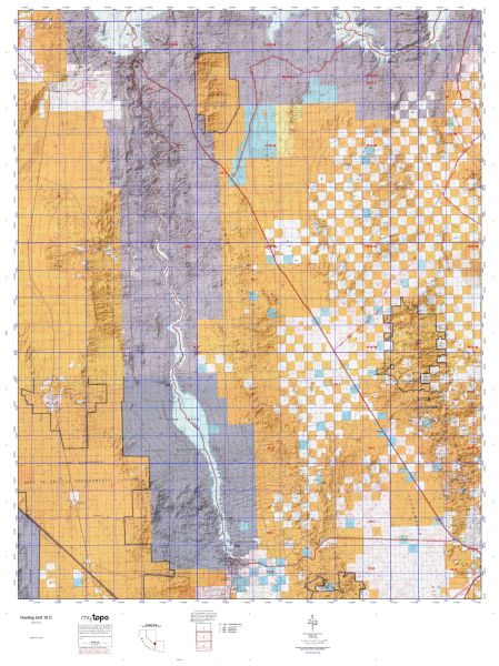
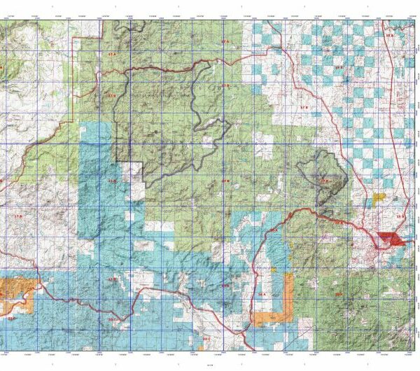
Unit 45 B Beginning at O-O Junction; north from O-O Junction on the Kofa Mine Road to the Evening Star Mine; north on a line over Polaris Mountain to Bidwell; north on the Bidwell-Alamo Spring-Kofa Cabin Road to the El Paso Natural Gas Pipeline Road; north on a line from the junction to the north Kofa National Wildlife Refuge boundary; east to the east refuge boundary; south and west along the Kofa National Wildlife Refuge boundary to the Stone Cabin-King Valley Road; north and west on the Stone Cabin-King Valley Road to O-O Junction.


Shopping cart
Sign in

No account yet?

Start typing to see products you are looking for.
Shop
0 Wishlist
0 items Cart
My account