Arizona Unit 27 Topo Maps Hunting & Unit Maps

arizona unit 27 hunting map

Arizona Unit 27 Topo Maps Hunting & Unit Maps

Currently there are 20 peoples are currently looking at this product

Spend $1,000.00 for FREE SHIPPING

Description
Customer Review

Reviews

There are no reviews yet.

Be the first to review “Arizona Unit 27 Topo Maps Hunting & Unit Maps”

Your email address will not be published. Required fields are marked *

Click Here to View Large Map or Order

Arizona Unit 27 hunting map topo with printed boundaries

HuntersDomain has Arizona unit 27 hunt area maps that are 1:100,000-scale maps using Bureau of Land Management land status base maps.

Our UNIT 27 maps include:

  1. Arizona public land ownership boundaries
  2. Topographical contour lines
  3. 1:100,000 scale for easy viewing
  4. Roads printed
  5. Key terrain features to help you plan your hunt or trip
  6. Hunt area or game management unit 27 (GMU 27) boundary is overlaid on the BLM base map
  7. Easy planning for your upcoming big game hunt by defining roads and routes into the preferred area

Custom maps for unit 27 are also available (See it all on one map):

  1. Color aerial photo maps: high resolution (you define borders/boundaries)
  2. TOPO maps only where you easily define borders or edges of maps with our online program
  3. Hybrid maps: a unique and detailed aerial photo combined withe USGS topographical maps (user-defined boundaries)

Order your unit 27 Arizona topo map today!

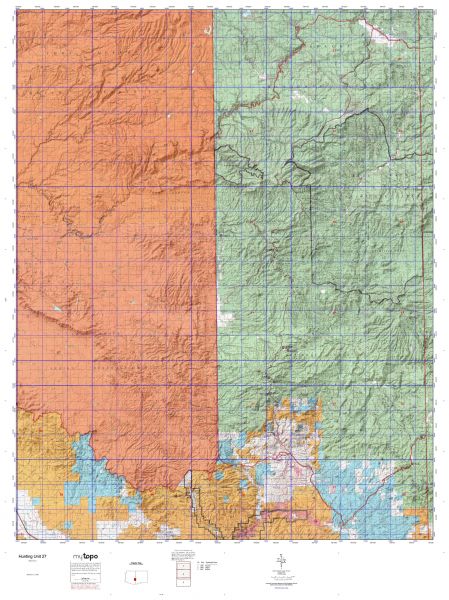
The actual boundary description/definitions printed below from the Arizona Division of Wildlife hunting regulations brochure could have errors or been amended by the state so always check in their most current printed regulations or the Arizona Division of Wildlife website to verify these boundaries before hunting as these are for reference only.

Arizona Big Game

Click Here to Order Unit 27 Topo Map

Unit description

Unit 27 Beginning at the New Mexico state line and Arizona Highway 78; southwest on Arizona Highway 78 to United States Highway 191; north on United States Highway 191 to San Carlos-Morenci-Clifton Road; west on San Carlos-Morenci-Clifton Road to Eagle Creek; north along Eagle Creek to the San Carlos Apache Indian Reservation boundary; north along the San Carlos Apache Indian Reservation boundary to Black River; northeast along Black River to the East Fork of Black River; northeast along the East Fork of Black River to Three Forks-Williams Valley-Alpine Road (Forest Road 249); easterly along Three Forks-Williams Valley-Alpine Road to United States Highway 180; southeast on United States Highway 180 to the New Mexico state line; south along the New Mexico state line to Arizona Highway 78.


Shopping cart
Sign in

No account yet?

Start typing to see products you are looking for.
Shop
0 Wishlist
0 items Cart
My account