Arizona Unit 2 A Topo Maps Hunting & Unit Maps 

Arizona Unit 2 A Topo Maps Hunting & Unit Maps 

Currently there are 20 peoples are currently looking at this product

Spend $1,000.00 for FREE SHIPPING

Description
Customer Review

Reviews

There are no reviews yet.

Be the first to review “Arizona Unit 2 A Topo Maps Hunting & Unit Maps ”

Your email address will not be published. Required fields are marked *

Click Here to View Large Map or Order

Arizona Unit 2 A hunting map topo with printed boundaries

HuntersDomain has Arizona unit 2 A hunting area maps that are 1:100,000-scale maps using Bureau of Land Management land status base maps.

Our UNIT 2 A maps include:

  1. Arizona public land ownership boundaries
  2. Topographical contour lines
  3. 1:100,000 scale for easy viewing
  4. Roads printed
  5. Key terrain features to help you plan your hunt or trip
  6. Hunt area or game management unit 2 A (GMU 2 A) boundary is overlaid on the BLM base map
  7. Easy planning for your upcoming big game hunt by defining roads and routes into the preferred area

Custom maps for unit 2 A are also available (See it all on one map):

  1. Color aerial photo maps: high resolution (you define borders/boundaries)
  2. TOPO maps only where you easily define borders or edges of maps with our online program
  3. Hybrid maps: a unique and detailed aerial photo combined withe USGS topographical maps (user-defined boundaries)

Order your unit 2 A Arizona topo map today!

The actual boundary description/definitions printed below from the Arizona Division of Wildlife hunting regulations brochure could have errors or been amended by the state so always check in their most current printed regulations or the Arizona Division of Wildlife website to verify these boundaries before hunting as these are for reference only.

Arizona Big Game

Click Here to Order Unit 2 A Topo Map

Unit description

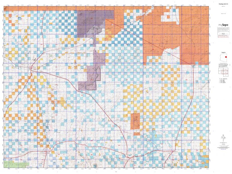
Unit 2 A Unit 2A — Beginning at Street Johnson United States Highway 191 (Arizona Highway 61); north on United States Highway 191 (Arizona Highway 61) to the Navajo Indian Reservation boundary; westerly along the reservation boundary to Arizona Highway 77; south on Arizona Highway 77 to Exit 292 on I-40; west on the westbound lane of Interstate-40 to Exit 286; south on Arizona Highway 77 to United States Highway 180; southeast on United States Highway 180 to Arizona Highway 180A; south on Arizona Highway 180A to Arizona Highway 61; east on Arizona Highway 61 to United States Highway 180 (Arizona Highway 61); east to United States Highway 191 at Street Johns; except those portions that are sovereign tribal lands of the Zuni Tribe.


Shopping cart
Sign in

No account yet?

Start typing to see products you are looking for.
Shop
0 Wishlist
0 items Cart
My account