Click Here to View Large Map or to Purchase
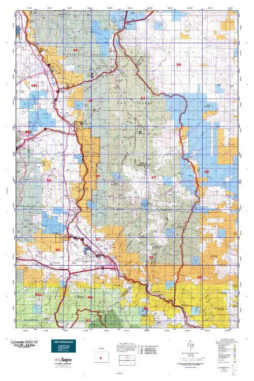
Colorado Unit 57 Hunting Topo Map with Printed Boundaries
Hunters Domain has Colorado Unit 57 hunt area maps that are 1:100,000-scale maps using Bureau of Land Management land status base maps.
Our UNIT 57 maps include:
Colorado public land ownership boundaries
Topographical contour lines
1:100,000 scale for easy viewing
Roads printed
Key terrain features to help you plan your hunt or trip
Hunt area or game management unit 57 (GMU 57) boundary is overlaid on the BLM base map
Easy planning for your upcoming big game hunt by defining roads and routes into the preferred area
Custom maps for Unit 57 are also available (See it all on one map):
Color aerial photo maps: high resolution (you define borders/boundaries)
TOPO maps only where you easily define borders or edges of maps with our online program
Hybrid maps: a unique and detailed aerial photo combined with a USGS topographical maps (user-defined boundaries)
Order your Colorado Unit 57 Map Today!
The actual boundary description/definitions printed below from Colorado Parks and Wildlife hunting regulations brochure could have errors or been amended by the state so always check in their most current printed regulations or the Colorado Parks and Wildlife website to verify these boundaries before hunting as these are for reference only.
Colorado Big Game Unit 57
– Unit 57 Topo/Map Colorado – Game Management Unit (GMU-57).
Game Management Unit (GMU)
BLM Maps:
Reservation Land
US Forest Service Maps:
Reservation land
Click Here to Order Your Color Colorado Unit 57 Hunting Map
Colorado Unit 57 Description
Unit 57 Located in Freemont, Chaffee and Park Counties bounded on the North by U.S. 24; on the East by Kaufman Ridge and Badger Creek; on the South and the West by the Arkansas River.
GMU 57 Elevation: 10,995 feet on Cameron Mountain to 6,890 feet near Swissvale. Terrain: Relatively level to moderately steep, low mountains with steep, rocky areas on the west side above the Arkansas River. Vegetation: Grassy meadows with large aspen stands, piñons, junipers, pines, spruce & fir. Weather: Variable, but expect snow or freeze in mid-Sept. or early Oct. Access during late season hunts may be limited due to snow. Land Status: approximately 80 percent public. Hunter Access: Good to public lands. Deer: Better deer areas are in the lower elevation piñons and junipers along the north, west and south sides of the unit. The areas around Turret are improving, and area near Wellsville should be good. Elk: Better elk hunting at higher elevations from about Cameron Mountain north to Trout Creek Pass. Be especially cautious around private property in the center of the unit. Private property is not always contiguous, property ownership maps are highly recommended in this portion of the unit.


Reviews
There are no reviews yet.